Garchitorena geodata
Garchitorena (Bicol) is a seat of a third-order administrative division; located in Philippines in Asia/Manila (GMT+8) time zone. With population of 4,909 people, there are 1335 cities with bigger population in this country. Compared to other cities in Philippines, 67.1% of cities are located further ↓South; 65.5% of cities are located further ←West and 97.1% of cities have higher elevation than Garchitorena. Note1


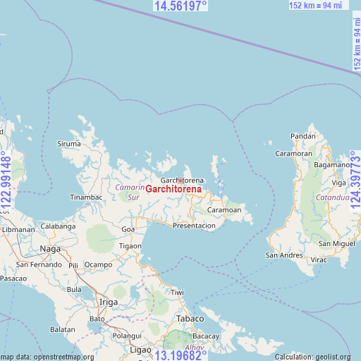
Garchitorena GPS coordinates[2]
13° 52' 49.44" North, 123° 41' 40.56" East
| Map corner | latitude | longitude |
|---|---|---|
| Upper-left | 14.56197°, | 122.99148° |
| Center: | 13.8804°, | 123.6946° |
| Lower-right: | 13.19682°, | 124.39773° |
| Map W x H: | 151.8×151.8 km | = 94.3×94.3mi |
| max Lat: | 20.78733° ⇑32.9% North |
| Garchitorena: | 13.8804° |
| min Lat: | ⇓67.1% South 4.65442° |
| min Long | Garchitorena | max Long |
| 117.04868° | 123.6946° | 126.58417° |
| W 65.5%⇐ | ⇒34.5% E |
Elevation
Elevation of Garchitorena is 4 m = 13 ft, and this is 83.9 m = 275 ft below average elevation for this country.
| Max E: |
2262 m = 7421 ft | 97.1% |
| Avg. | 87.9 m = 288 ft | |
| Garchitorena | 4 m = 13 ft | |
Min E: |
-2 m = -7 ft | 2.9% |
See also: Philippines elevation on elevation.city.
Geographical zone
Garchitorena is located in North Torrid zone (between Equator and Tropic of Cancer). Distance of this Northern Tropic circle is 1062.6 km =660.3 mi to North.| Distance of | km | miles | from Garchitorena |
|---|---|---|---|
| North Pole | 8463.7 | 5259.1 | to North |
| Arctic Circle | 5857.8 | 3639.9 | to North |
| Tropic Cancer | 1062.6 | 660.3 | to North |
| Equator | 1543.4 | 959 | to South |


Nearby cities:
15 places around Garchitorena: (largest is in red/bold)
• Buyo
32.6 km =20.3 mi,  227°
227°
• Caramoan
21.9 km =13.6 mi,  123°
123°
• Gibgos
8.2 km =5.1 mi,  106°
106°
• Goa
30.1 km =18.7 mi, 227°
• Guijalo
24.6 km =15.3 mi,  130°
130°
• Kinalansan
24.9 km =15.5 mi,  217°
217°
• Lagonoy
24.8 km =15.4 mi, 229°
• Maagnas
18.2 km =11.3 mi,  189°
189°
• Parabcan
19.8 km =12.3 mi,  164°
164°
• Sabang
21.7 km =13.5 mi, 215°
• Salogon
30.9 km =19.2 mi, 217°
• San Jose
27.7 km =17.2 mi, 223°
• San Ramon
24.3 km =15.1 mi, 223°
• San Sebastian
20.1 km =12.5 mi,  212°
212°
• Tinawagan
34.3 km =21.3 mi, 221°
Sources, notices
• [Note1] Compared only with cities in Philippines existing in our database
• [Src1] Map data: © OpenStreetMap contributors (CC-BY-SA)
• [Src2] Other city data from geonames.org with taken over terms of usage.
• [Src3] Geographical zone / Annual Mean Temperature by Robert A. Rohde @ Wikipedia
