Guadalupe geodata
Guadalupe (Western Visayas) is a populated place; located in Philippines in Asia/Manila (GMT+8) time zone. With population of 11,053 people, there are 557 cities with bigger population in this country. Compared to other cities in Philippines, 63.7% of cities are located further ↑North; 59.8% of cities are located further ←West and 92.7% of cities have higher elevation than Guadalupe. Note1
Administrative division(s):
- Level 1: Western Visayas
- Level 2: Province of Negros Occidental
- Level 3: San Carlos City


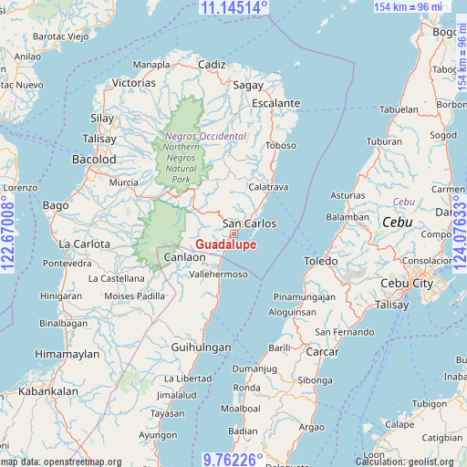
Guadalupe GPS coordinates[2]
10° 27' 16.092" North, 123° 22' 23.52" East
| Map corner | latitude | longitude |
|---|---|---|
| Upper-left | 11.14514°, | 122.67008° |
| Center: | 10.45447°, | 123.3732° |
| Lower-right: | 9.76226°, | 124.07633° |
| Map W x H: | 153.8×153.8 km | = 95.6×95.6mi |
| max Lat: | 20.78733° ⇑63.7% North |
| Guadalupe: | 10.45447° |
| min Lat: | ⇓36.3% South 4.65442° |
| min Long | Guadalupe | max Long |
| 117.04868° | 123.3732° | 126.58417° |
| W 59.8%⇐ | ⇒40.2% E |
Elevation
Elevation of Guadalupe is 6 m = 20 ft, and this is 81.9 m = 269 ft below average elevation for this country.
| Max E: |
2262 m = 7421 ft | 92.7% |
| Avg. | 87.9 m = 288 ft | |
| Guadalupe | 6 m = 20 ft | |
Min E: |
-2 m = -7 ft | 7.3% |
See also: Philippines elevation on elevation.city.
Geographical zone
Guadalupe is located in North Torrid zone (between Equator and Tropic of Cancer). Distance of Equator is 1162.4 km =722.3 mi to South.| Distance of | km | miles | from Guadalupe |
|---|---|---|---|
| North Pole | 8844.6 | 5495.8 | to North |
| Arctic Circle | 6238.7 | 3876.5 | to North |
| Tropic Cancer | 1443.5 | 896.9 | to North |
| Equator | 1162.4 | 722.3 | to South |


Nearby cities:
15 places around Guadalupe: (largest is in red/bold)
• Agpangi
14.7 km =9.1 mi,  21°
21°
• Buenavista
12.9 km =8 mi,  39°
39°
• Buluangan
8.4 km =5.2 mi,  207°
207°
• Codcod
13.6 km =8.5 mi,  274°
274°
• Hacienda Refugio
10.8 km =6.7 mi,  46°
46°
• Malaiba
14.8 km =9.2 mi,  204°
204°
• Palampas
9.4 km =5.8 mi,  33°
33°
• Patonan
16.6 km =10.3 mi, 40°
• Pinokawan
15.3 km =9.5 mi, 214°
• Prosperidad
9.8 km =6.1 mi,  314°
314°
• Punao
12.9 km =8 mi, 17°
• Quezon
12.5 km =7.8 mi,  260°
260°
• Tabon
17.7 km =11 mi, 196°
• Ualog
13.5 km =8.4 mi,  9°
9°
• Vallehermoso
14.3 km =8.9 mi, 201°
Sources, notices
• [Note1] Compared only with cities in Philippines existing in our database
• [Src1] Map data: © OpenStreetMap contributors (CC-BY-SA)
• [Src2] Other city data from geonames.org with taken over terms of usage.
• [Src3] Geographical zone / Annual Mean Temperature by Robert A. Rohde @ Wikipedia
