Opol geodata
Opol (Northern Mindanao) is a populated place; located in Philippines in Asia/Manila (GMT+8) time zone. With population of 3,468 people, there are 2082 cities with bigger population in this country. Compared to other cities in Philippines, 78.5% of cities are located further ↑North; 80.2% of cities are located further ←West and 60.8% of cities have higher elevation than Opol. Note1
Administrative division(s):
- Level 1: Northern Mindanao
- Level 2: Province of Misamis Oriental
- Level 3: Opol


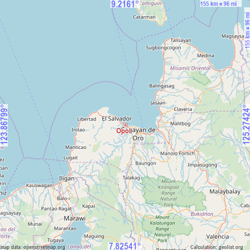
Opol GPS coordinates[2]
8° 31' 17.004" North, 124° 34' 15.996" East
| Map corner | latitude | longitude |
|---|---|---|
| Upper-left | 9.2161°, | 123.86799° |
| Center: | 8.52139°, | 124.57111° |
| Lower-right: | 7.82541°, | 125.27424° |
| Map W x H: | 154.6×154.6 km | = 96.1×96.1mi |
| max Lat: | 20.78733° ⇑78.5% North |
| Opol: | 8.52139° |
| min Lat: | ⇓21.5% South 4.65442° |
| min Long | Opol | max Long |
| 117.04868° | 124.57111° | 126.58417° |
| W 80.2%⇐ | ⇒19.8% E |
Elevation
Elevation of Opol is 16 m = 52 ft, and this is 71.9 m = 236 ft below average elevation for this country.
| Max E: |
2262 m = 7421 ft | 60.8% |
| Avg. | 87.9 m = 288 ft | |
| Opol | 16 m = 52 ft | |
Min E: |
-2 m = -7 ft | 39.2% |
See also: Philippines elevation on elevation.city.
Geographical zone
Opol is located in North Torrid zone (between Equator and Tropic of Cancer). Distance of Equator is 947.5 km =588.7 mi to South.| Distance of | km | miles | from Opol |
|---|---|---|---|
| North Pole | 9059.6 | 5629.4 | to North |
| Arctic Circle | 6453.7 | 4010.1 | to North |
| Tropic Cancer | 1658.4 | 1030.5 | to North |
| Equator | 947.5 | 588.7 | to South |


Nearby cities:
15 places around Opol: (largest is in red/bold)
• Agusan
18.6 km =11.6 mi,  100°
100°
• Alubijid
12.2 km =7.6 mi,  298°
298°
• Baikingon
5.8 km =3.6 mi,  199°
199°
• Barra
3.9 km =2.4 mi,  108°
108°
• Bolo Bolo
6.1 km =3.8 mi,  312°
312°
• Cagayan de Oro
9.4 km =5.8 mi,  117°
117°
• El Salvador
7.1 km =4.4 mi, 310°
• Igpit
2.1 km =1.3 mi, 124°
• Lagindingan
15.4 km =9.6 mi,  292°
292°
• Lourdes
15.3 km =9.5 mi,  271°
271°
• Lumbia
14.2 km =8.8 mi,  169°
169°
• Molugan
2 km =1.2 mi,  331°
331°
• Moog
14.6 km =9.1 mi, 307°
• Taypano
16.8 km =10.4 mi,  184°
184°
• Taytay
4.1 km =2.5 mi, 302°
Sources, notices
• [Note1] Compared only with cities in Philippines existing in our database
• [Src1] Map data: © OpenStreetMap contributors (CC-BY-SA)
• [Src2] Other city data from geonames.org with taken over terms of usage.
• [Src3] Geographical zone / Annual Mean Temperature by Robert A. Rohde @ Wikipedia
