Pilar geodata
Pilar (Central Visayas) is a seat of a third-order administrative division; located in Philippines in Asia/Manila (GMT+8) time zone. With population of 2,812 people, there are 2774 cities with bigger population in this country. Compared to other cities in Philippines, 70% of cities are located further ↑North; 76.2% of cities are located further ←West and 87.1% of cities have lower elevation than Pilar. Note1


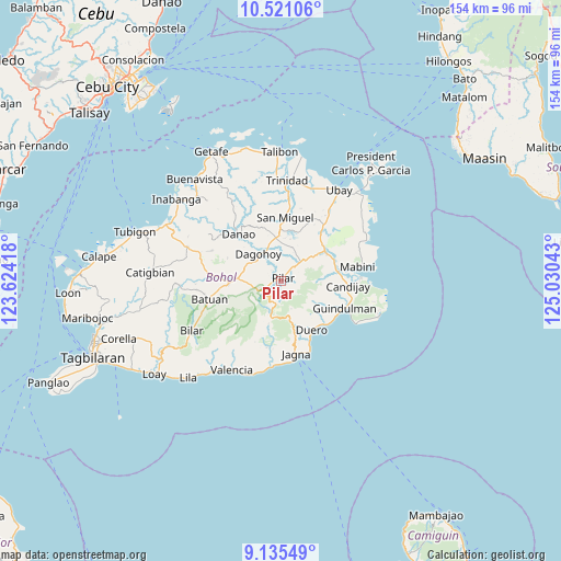
Pilar GPS coordinates[2]
9° 49' 44.4" North, 124° 19' 38.28" East
| Map corner | latitude | longitude |
|---|---|---|
| Upper-left | 10.52106°, | 123.62418° |
| Center: | 9.829°, | 124.3273° |
| Lower-right: | 9.13549°, | 125.03043° |
| Map W x H: | 154.1×154.1 km | = 95.8×95.8mi |
| max Lat: | 20.78733° ⇑70% North |
| Pilar: | 9.829° |
| min Lat: | ⇓30% South 4.65442° |
| min Long | Pilar | max Long |
| 117.04868° | 124.3273° | 126.58417° |
| W 76.2%⇐ | ⇒23.8% E |
Elevation
Elevation of Pilar is 167 m = 548 ft, and this is 79.1 m = 260 ft above average elevation for this country.
| Max E: |
2262 m = 7421 ft | 12.9% |
| Pilar | 167 m 548 ft | |
| Avg. | 87.9 m = 288 ft | |
Min E: |
-2 m = -7 ft | 87.1% |
See also: Philippines elevation on elevation.city.
Geographical zone
Pilar is located in North Torrid zone (between Equator and Tropic of Cancer). Distance of Equator is 1092.9 km =679.1 mi to South.| Distance of | km | miles | from Pilar |
|---|---|---|---|
| North Pole | 8914.2 | 5539 | to North |
| Arctic Circle | 6308.3 | 3919.8 | to North |
| Tropic Cancer | 1513 | 940.1 | to North |
| Equator | 1092.9 | 679.1 | to South |


Nearby cities:
15 places around Pilar: (largest is in red/bold)
• Alicia
14.6 km =9.1 mi,  59°
59°
• Biabas
15.6 km =9.7 mi,  101°
101°
• Buenavista
11.6 km =7.2 mi,  276°
276°
• Bugsoc
8 km =5 mi,  230°
230°
• Carmen
14.4 km =8.9 mi,  267°
267°
• Dagohoy
9.3 km =5.8 mi,  328°
328°
• Duero
15.9 km =9.9 mi,  147°
147°
• La Hacienda
9.2 km =5.7 mi,  50°
50°
• Lombog
11.3 km =7 mi,  119°
119°
• Mahayag
11.8 km =7.3 mi,  354°
354°
• Mayana
8.6 km =5.3 mi,  161°
161°
• San Isidro
10.4 km =6.5 mi, 231°
• San Miguel
6.2 km =3.9 mi,  359°
359°
• Sierra Bullones
4.5 km =2.8 mi,  238°
238°
• Valle Hermoso
10.7 km =6.6 mi,  248°
248°
Sources, notices
• [Note1] Compared only with cities in Philippines existing in our database
• [Src1] Map data: © OpenStreetMap contributors (CC-BY-SA)
• [Src2] Other city data from geonames.org with taken over terms of usage.
• [Src3] Geographical zone / Annual Mean Temperature by Robert A. Rohde @ Wikipedia
