Dulangan geodata
Dulangan (Mimaropa) is a populated place; located in Philippines in Asia/Manila (GMT+8) time zone. With population of 3,995 people, there are 1735 cities with bigger population in this country. Compared to other cities in Philippines, 60.1% of cities are located further ↓South; 73.4% of cities are located further →East and 62.8% of cities have higher elevation than Dulangan. Note1
Administrative division(s):
- Level 1: Mimaropa
- Level 2: Province of Mindoro Oriental
- Level 3: City of Calapan


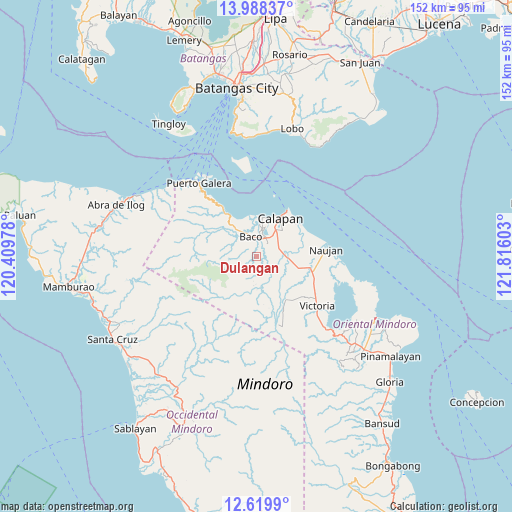
Dulangan GPS coordinates[2]
13° 18' 18.36" North, 121° 6' 46.44" East
| Map corner | latitude | longitude |
|---|---|---|
| Upper-left | 13.98837°, | 120.40978° |
| Center: | 13.3051°, | 121.1129° |
| Lower-right: | 12.6199°, | 121.81603° |
| Map W x H: | 152.2×152.2 km | = 94.6×94.6mi |
| max Lat: | 20.78733° ⇑39.9% North |
| Dulangan: | 13.3051° |
| min Lat: | ⇓60.1% South 4.65442° |
| min Long | Dulangan | max Long |
| 117.04868° | 121.1129° | 126.58417° |
| W 26.6%⇐ | ⇒73.4% E |
Elevation
Elevation of Dulangan is 15 m = 49 ft, and this is 72.9 m = 239 ft below average elevation for this country.
| Max E: |
2262 m = 7421 ft | 62.8% |
| Avg. | 87.9 m = 288 ft | |
| Dulangan | 15 m = 49 ft | |
Min E: |
-2 m = -7 ft | 37.2% |
See also: Philippines elevation on elevation.city.
Geographical zone
Dulangan is located in North Torrid zone (between Equator and Tropic of Cancer). Distance of this Northern Tropic circle is 1126.5 km =700 mi to North.| Distance of | km | miles | from Dulangan |
|---|---|---|---|
| North Pole | 8527.7 | 5298.9 | to North |
| Arctic Circle | 5921.8 | 3679.6 | to North |
| Tropic Cancer | 1126.5 | 700 | to North |
| Equator | 1479.4 | 919.3 | to South |


Nearby cities:
15 places around Dulangan: (largest is in red/bold)
• Apitong
12.6 km =7.8 mi,  125°
125°
• Aurora
8.1 km =5 mi,  174°
174°
• Baco
6 km =3.7 mi,  344°
344°
• Bayanan
8.6 km =5.3 mi,  45°
45°
• Biga
5.2 km =3.2 mi,  83°
83°
• Calapan
13.9 km =8.6 mi,  31°
31°
• Canubing No 2
5.5 km =3.4 mi,  23°
23°
• Communal
6.2 km =3.9 mi,  155°
155°
• Evangelista
3.6 km =2.2 mi,  331°
331°
• Lumangbayan
15.2 km =9.4 mi, 326°
• Manogpi
9.9 km =6.2 mi,  86°
86°
• Pinagsabangan
17.4 km =10.8 mi,  104°
104°
• San Vincente
13.2 km =8.2 mi, 30°
• Sapol
10.6 km =6.6 mi, 51°
• Tacligan
11.6 km =7.2 mi, 332°
Sources, notices
• [Note1] Compared only with cities in Philippines existing in our database
• [Src1] Map data: © OpenStreetMap contributors (CC-BY-SA)
• [Src2] Other city data from geonames.org with taken over terms of usage.
• [Src3] Geographical zone / Annual Mean Temperature by Robert A. Rohde @ Wikipedia
