Biga geodata
Biga (Central Luzon) is a populated place; located in Philippines in Asia/Manila (GMT+8) time zone. With population of 2,365 people, there are 3528 cities with bigger population in this country. Compared to other cities in Philippines, 60.1% of cities are located further ↓South; 72.3% of cities are located further →East and 59.2% of cities have higher elevation than Biga. Note1


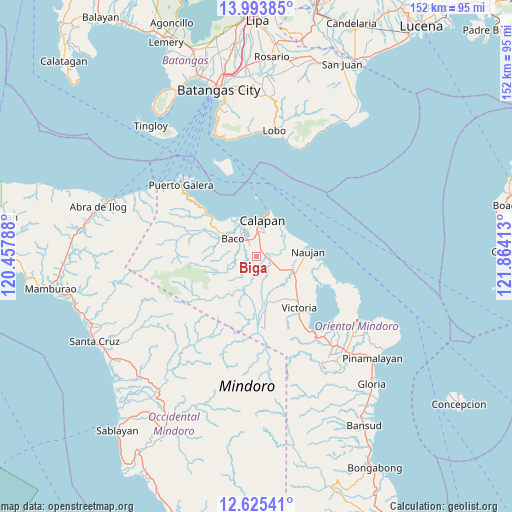
Biga GPS coordinates[2]
13° 18' 38.16" North, 121° 9' 39.6" East
| Map corner | latitude | longitude |
|---|---|---|
| Upper-left | 13.99385°, | 120.45788° |
| Center: | 13.3106°, | 121.161° |
| Lower-right: | 12.62541°, | 121.86413° |
| Map W x H: | 152.2×152.2 km | = 94.6×94.6mi |
| max Lat: | 20.78733° ⇑39.9% North |
| Biga: | 13.3106° |
| min Lat: | ⇓60.1% South 4.65442° |
| min Long | Biga | max Long |
| 117.04868° | 121.161° | 126.58417° |
| W 27.7%⇐ | ⇒72.3% E |
Elevation
Elevation of Biga is 17 m = 56 ft, and this is 70.9 m = 233 ft below average elevation for this country.
| Max E: |
2262 m = 7421 ft | 59.2% |
| Avg. | 87.9 m = 288 ft | |
| Biga | 17 m = 56 ft | |
Min E: |
-2 m = -7 ft | 40.8% |
See also: Philippines elevation on elevation.city.
Geographical zone
Biga is located in North Torrid zone (between Equator and Tropic of Cancer). Distance of this Northern Tropic circle is 1125.9 km =699.6 mi to North.| Distance of | km | miles | from Biga |
|---|---|---|---|
| North Pole | 8527.1 | 5298.5 | to North |
| Arctic Circle | 5921.2 | 3679.3 | to North |
| Tropic Cancer | 1125.9 | 699.6 | to North |
| Equator | 1480 | 919.6 | to South |


Nearby cities:
15 places around Biga: (largest is in red/bold)
• Apitong
9.4 km =5.8 mi,  147°
147°
• Aurora
9.8 km =6.1 mi,  206°
206°
• Baco
8.5 km =5.3 mi,  307°
307°
• Bayanan
5.5 km =3.4 mi,  10°
10°
• Calapan
11.4 km =7.1 mi, 10°
• Canubing No 2
5.3 km =3.3 mi,  325°
325°
• Communal
6.7 km =4.2 mi,  203°
203°
• Dulangan
5.2 km =3.2 mi,  263°
263°
• Evangelista
7.4 km =4.6 mi,  290°
290°
• Manogpi
4.7 km =2.9 mi,  89°
89°
• Nagiba
12.5 km =7.8 mi,  79°
79°
• Pinagsabangan
12.6 km =7.8 mi,  113°
113°
• San Vincente
10.8 km =6.7 mi, 8°
• Sapol
6.8 km =4.2 mi,  26°
26°
• Tacligan
14.4 km =8.9 mi, 312°
Sources, notices
• [Note1] Compared only with cities in Philippines existing in our database
• [Src1] Map data: © OpenStreetMap contributors (CC-BY-SA)
• [Src2] Other city data from geonames.org with taken over terms of usage.
• [Src3] Geographical zone / Annual Mean Temperature by Robert A. Rohde @ Wikipedia
