Calapan geodata
Calapan (Mimaropa) is a seat of a first-order administrative division; located in Philippines in Asia/Manila (GMT+8) time zone. With population of 66,008 people, there are 142 cities with bigger population in this country. Compared to other cities in Philippines, 61.3% of cities are located further ↓South; 72.1% of cities are located further →East and 85.4% of cities have higher elevation than Calapan. Note1
Administrative division(s):
- Level 1: Mimaropa
- Level 2: Province of Mindoro Oriental
- Level 3: City of Calapan


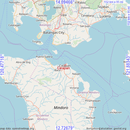
Calapan GPS coordinates[2]
13° 24' 42.12" North, 121° 10' 49.08" East
| Map corner | latitude | longitude |
|---|---|---|
| Upper-left | 14.09466°, | 120.47718° |
| Center: | 13.4117°, | 121.1803° |
| Lower-right: | 12.72679°, | 121.88343° |
| Map W x H: | 152.1×152.1 km | = 94.5×94.5mi |
| max Lat: | 20.78733° ⇑38.7% North |
| Calapan: | 13.4117° |
| min Lat: | ⇓61.3% South 4.65442° |
| min Long | Calapan | max Long |
| 117.04868° | 121.1803° | 126.58417° |
| W 27.9%⇐ | ⇒72.1% E |
Elevation
Elevation of Calapan is 8 m = 26 ft, and this is 79.9 m = 262 ft below average elevation for this country.
| Max E: |
2262 m = 7421 ft | 85.4% |
| Avg. | 87.9 m = 288 ft | |
| Calapan | 8 m = 26 ft | |
Min E: |
-2 m = -7 ft | 14.6% |
See also: Calapan elevation on elevation.city.
Geographical zone
Calapan is located in North Torrid zone (between Equator and Tropic of Cancer). Distance of this Northern Tropic circle is 1114.7 km =692.6 mi to North.| Distance of | km | miles | from Calapan |
|---|---|---|---|
| North Pole | 8515.8 | 5291.5 | to North |
| Arctic Circle | 5909.9 | 3672.2 | to North |
| Tropic Cancer | 1114.7 | 692.6 | to North |
| Equator | 1491.2 | 926.6 | to South |


Nearby cities:
15 places around Calapan: (largest is in red/bold)
• Baco
10.7 km =6.6 mi,  235°
235°
• Bayanan
5.9 km =3.7 mi,  190°
190°
• Biga
11.4 km =7.1 mi, 190°
• Canubing No 2
8.5 km =5.3 mi,  216°
216°
• Communal
18.1 km =11.2 mi,  195°
195°
• Dulangan
13.9 km =8.6 mi,  211°
211°
• Estrella
16.9 km =10.5 mi,  123°
123°
• Evangelista
12.5 km =7.8 mi,  225°
225°
• Lumangbayan
15.8 km =9.8 mi,  272°
272°
• Manogpi
11.5 km =7.1 mi,  167°
167°
• Nagiba
13.6 km =8.5 mi,  131°
131°
• Naujan
16.5 km =10.3 mi, 126°
• San Vincente
0.8 km =0.5 mi, 226°
• Sapol
5.3 km =3.3 mi, 169°
• Tacligan
12.8 km =8 mi,  262°
262°
Sources, notices
• [Note1] Compared only with cities in Philippines existing in our database
• [Src1] Map data: © OpenStreetMap contributors (CC-BY-SA)
• [Src2] Other city data from geonames.org with taken over terms of usage.
• [Src3] Geographical zone / Annual Mean Temperature by Robert A. Rohde @ Wikipedia
