Ula geodata
Ula (Davao) is a populated place; located in Philippines in Asia/Manila (GMT+8) time zone. With population of 2,689 people, there are 2966 cities with bigger population in this country. Compared to other cities in Philippines, 90.3% of cities are located further ↑North; 93.4% of cities are located further ←West and 89.2% of cities have lower elevation than Ula. Note1


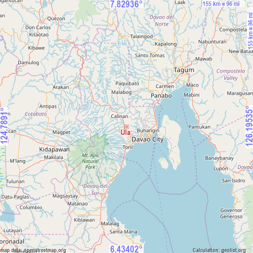
Ula GPS coordinates[2]
7° 7' 55.992" North, 125° 29' 31.992" East
| Map corner | latitude | longitude |
|---|---|---|
| Upper-left | 7.82936°, | 124.7891° |
| Center: | 7.13222°, | 125.49222° |
| Lower-right: | 6.43402°, | 126.19535° |
| Map W x H: | 155.1×155.2 km | = 96.4×96.4mi |
| max Lat: | 20.78733° ⇑90.3% North |
| Ula: | 7.13222° |
| min Lat: | ⇓9.7% South 4.65442° |
| min Long | Ula | max Long |
| 117.04868° | 125.49222° | 126.58417° |
| W 93.4%⇐ | ⇒6.6% E |
Elevation
Elevation of Ula is 210 m = 689 ft, and this is 122.1 m = 401 ft above average elevation for this country.
| Max E: |
2262 m = 7421 ft | 10.8% |
| Ula | 210 m 689 ft | |
| Avg. | 87.9 m = 288 ft | |
Min E: |
-2 m = -7 ft | 89.2% |
See also: Philippines elevation on elevation.city.
Geographical zone
Ula is located in North Torrid zone (between Equator and Tropic of Cancer). Distance of Equator is 793 km =492.7 mi to South.| Distance of | km | miles | from Ula |
|---|---|---|---|
| North Pole | 9214 | 5725.3 | to North |
| Arctic Circle | 6608.1 | 4106.1 | to North |
| Tropic Cancer | 1812.9 | 1126.5 | to North |
| Equator | 793 | 492.7 | to South |


Nearby cities:
15 places around Ula: (largest is in red/bold)
• Bato
10.1 km =6.3 mi,  192°
192°
• Biao
4.7 km =2.9 mi,  42°
42°
• Dacudao
9.5 km =5.9 mi,  346°
346°
• Davao
14.8 km =9.2 mi,  116°
116°
• Gumalang
12.9 km =8 mi,  310°
310°
• Lacson
10.4 km =6.5 mi,  328°
328°
• Malagos
9.7 km =6 mi, 307°
• Sirib
9.4 km =5.8 mi,  270°
270°
• Tagakpan
7.3 km =4.5 mi,  252°
252°
• Tamayong
12.4 km =7.7 mi, 270°
• Tamugan
16.8 km =10.4 mi, 310°
• Tawan tawan
13.8 km =8.6 mi,  287°
287°
• Tuli
14 km =8.7 mi,  323°
323°
• Wañgan
6 km =3.7 mi,  300°
300°
• Wines
13.3 km =8.3 mi, 301°
Sources, notices
• [Note1] Compared only with cities in Philippines existing in our database
• [Src1] Map data: © OpenStreetMap contributors (CC-BY-SA)
• [Src2] Other city data from geonames.org with taken over terms of usage.
• [Src3] Geographical zone / Annual Mean Temperature by Robert A. Rohde @ Wikipedia
