Consuelo geodata
Consuelo (Western Visayas) is a populated place; located in Philippines in Asia/Manila (GMT+8) time zone. With population of 4,543 people, there are 1470 cities with bigger population in this country. Compared to other cities in Philippines, 68.2% of cities are located further ↑North; 50.6% of cities are located further →East and 85.4% of cities have higher elevation than Consuelo. Note1
Administrative division(s):
- Level 1: Western Visayas
- Level 2: Province of Negros Occidental
- Level 3: Ilog


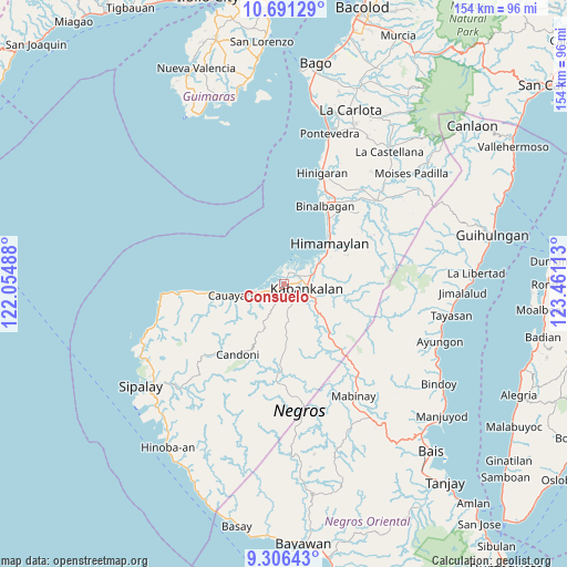
Consuelo GPS coordinates[2]
9° 59' 58.56" North, 122° 45' 28.8" East
| Map corner | latitude | longitude |
|---|---|---|
| Upper-left | 10.69129°, | 122.05488° |
| Center: | 9.9996°, | 122.758° |
| Lower-right: | 9.30643°, | 123.46113° |
| Map W x H: | 154×154 km | = 95.7×95.7mi |
| max Lat: | 20.78733° ⇑68.2% North |
| Consuelo: | 9.9996° |
| min Lat: | ⇓31.8% South 4.65442° |
| min Long | Consuelo | max Long |
| 117.04868° | 122.758° | 126.58417° |
| W 49.4%⇐ | ⇒50.6% E |
Elevation
Elevation of Consuelo is 8 m = 26 ft, and this is 79.9 m = 262 ft below average elevation for this country.
| Max E: |
2262 m = 7421 ft | 85.4% |
| Avg. | 87.9 m = 288 ft | |
| Consuelo | 8 m = 26 ft | |
Min E: |
-2 m = -7 ft | 14.6% |
See also: Philippines elevation on elevation.city.
Geographical zone
Consuelo is located in North Torrid zone (between Equator and Tropic of Cancer). Distance of Equator is 1111.9 km =690.9 mi to South.| Distance of | km | miles | from Consuelo |
|---|---|---|---|
| North Pole | 8895.2 | 5527.2 | to North |
| Arctic Circle | 6289.3 | 3908 | to North |
| Tropic Cancer | 1494.1 | 928.4 | to North |
| Equator | 1111.9 | 690.9 | to South |


Nearby cities:
15 places around Consuelo: (largest is in red/bold)
• Bocana
4.2 km =2.6 mi,  288°
288°
• Camingawan
16.3 km =10.1 mi,  135°
135°
• Cawayan
14.9 km =9.3 mi,  258°
258°
• Daliciasao
1.6 km =1 mi,  164°
164°
• Dancalan
2.9 km =1.8 mi,  227°
227°
• Guiljungan
9.4 km =5.8 mi, 256°
• Himamaylan
16.5 km =10.3 mi,  48°
48°
• Ilog
3.2 km =2 mi,  20°
20°
• Kabankalan
6.4 km =4 mi,  105°
105°
• Manalad
2.2 km =1.4 mi,  72°
72°
• Orong
10.4 km =6.5 mi,  131°
131°
• Suay
11 km =6.8 mi,  57°
57°
• Tabu
13 km =8.1 mi,  203°
203°
• Tiling
11.7 km =7.3 mi, 255°
• Vista Alegre
0.9 km =0.6 mi,  98°
98°
Sources, notices
• [Note1] Compared only with cities in Philippines existing in our database
• [Src1] Map data: © OpenStreetMap contributors (CC-BY-SA)
• [Src2] Other city data from geonames.org with taken over terms of usage.
• [Src3] Geographical zone / Annual Mean Temperature by Robert A. Rohde @ Wikipedia
