Suay geodata
Suay (Western Visayas) is a populated place; located in Philippines in Asia/Manila (GMT+8) time zone. With population of 19,672 people, there are 372 cities with bigger population in this country. Compared to other cities in Philippines, 67.9% of cities are located further ↑North; 50.5% of cities are located further ←West and 73.2% of cities have higher elevation than Suay. Note1
Administrative division(s):
- Level 1: Western Visayas
- Level 2: Province of Negros Occidental
- Level 3: City of Himamaylan


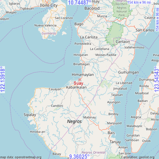
Suay GPS coordinates[2]
10° 3' 11.88" North, 122° 50' 32.28" East
| Map corner | latitude | longitude |
|---|---|---|
| Upper-left | 10.74487°, | 122.13918° |
| Center: | 10.0533°, | 122.8423° |
| Lower-right: | 9.36025°, | 123.54543° |
| Map W x H: | 154×154 km | = 95.7×95.7mi |
| max Lat: | 20.78733° ⇑67.9% North |
| Suay: | 10.0533° |
| min Lat: | ⇓32.1% South 4.65442° |
| min Long | Suay | max Long |
| 117.04868° | 122.8423° | 126.58417° |
| W 50.5%⇐ | ⇒49.5% E |
Elevation
Elevation of Suay is 11 m = 36 ft, and this is 76.9 m = 252 ft below average elevation for this country.
| Max E: |
2262 m = 7421 ft | 73.2% |
| Avg. | 87.9 m = 288 ft | |
| Suay | 11 m = 36 ft | |
Min E: |
-2 m = -7 ft | 26.8% |
See also: Philippines elevation on elevation.city.
Geographical zone
Suay is located in North Torrid zone (between Equator and Tropic of Cancer). Distance of Equator is 1117.8 km =694.6 mi to South.| Distance of | km | miles | from Suay |
|---|---|---|---|
| North Pole | 8889.2 | 5523.5 | to North |
| Arctic Circle | 6283.4 | 3904.3 | to North |
| Tropic Cancer | 1488.1 | 924.7 | to North |
| Equator | 1117.8 | 694.6 | to South |


Nearby cities:
15 places around Suay: (largest is in red/bold)
• Aguisan
12.1 km =7.5 mi,  10°
10°
• Cabanbanan
13.1 km =8.1 mi,  74°
74°
• Carabalan
12.3 km =7.6 mi, 67°
• Consuelo
11 km =6.8 mi,  237°
237°
• Daliciasao
11.6 km =7.2 mi,  229°
229°
• Dancalan
13.8 km =8.6 mi, 235°
• Himamaylan
5.9 km =3.7 mi,  31°
31°
• Ilog
8.6 km =5.3 mi,  249°
249°
• Kabankalan
8.3 km =5.2 mi,  201°
201°
• Mambagatan
8 km =5 mi,  38°
38°
• Manalad
8.9 km =5.5 mi, 233°
• Nato
10.9 km =6.8 mi, 11°
• Orong
13 km =8.1 mi,  186°
186°
• Talaban
8.5 km =5.3 mi,  18°
18°
• Vista Alegre
10.3 km =6.4 mi, 233°
Sources, notices
• [Note1] Compared only with cities in Philippines existing in our database
• [Src1] Map data: © OpenStreetMap contributors (CC-BY-SA)
• [Src2] Other city data from geonames.org with taken over terms of usage.
• [Src3] Geographical zone / Annual Mean Temperature by Robert A. Rohde @ Wikipedia
