Cogon geodata
Cogon (Central Visayas) is a populated place; located in Philippines in Asia/Manila (GMT+8) time zone. With population of 3,204 people, there are 2299 cities with bigger population in this country. Compared to other cities in Philippines, 65.5% of cities are located further ↑North; 67.1% of cities are located further ←West and 77% of cities have lower elevation than Cogon. Note1


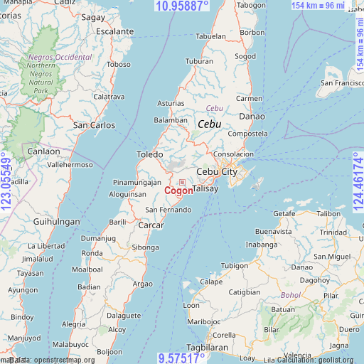
Cogon GPS coordinates[2]
10° 16' 4.008" North, 123° 45' 30.996" East
| Map corner | latitude | longitude |
|---|---|---|
| Upper-left | 10.95887°, | 123.05549° |
| Center: | 10.26778°, | 123.75861° |
| Lower-right: | 9.57517°, | 124.46174° |
| Map W x H: | 153.9×153.9 km | = 95.6×95.6mi |
| max Lat: | 20.78733° ⇑65.5% North |
| Cogon: | 10.26778° |
| min Lat: | ⇓34.5% South 4.65442° |
| min Long | Cogon | max Long |
| 117.04868° | 123.75861° | 126.58417° |
| W 67.1%⇐ | ⇒32.9% E |
Elevation
Elevation of Cogon is 75 m = 246 ft, and this is 12.9 m = 42 ft below average elevation for this country.
| Max E: |
2262 m = 7421 ft | 23% |
| Avg. | 87.9 m = 288 ft | |
| Cogon | 75 m = 246 ft | |
Min E: |
-2 m = -7 ft | 77% |
See also: Philippines elevation on elevation.city.
Geographical zone
Cogon is located in North Torrid zone (between Equator and Tropic of Cancer). Distance of Equator is 1141.7 km =709.4 mi to South.| Distance of | km | miles | from Cogon |
|---|---|---|---|
| North Pole | 8865.4 | 5508.7 | to North |
| Arctic Circle | 6259.5 | 3889.5 | to North |
| Tropic Cancer | 1464.2 | 909.8 | to North |
| Equator | 1141.7 | 709.4 | to South |


Nearby cities:
15 places around Cogon: (largest is in red/bold)
• Alpaco
8.7 km =5.4 mi,  252°
252°
• Bairan
8.6 km =5.3 mi,  203°
203°
• Cantao-an
3 km =1.9 mi, 199°
• Guindarohan
1.1 km =0.7 mi,  134°
134°
• Inayagan
3.8 km =2.4 mi,  162°
162°
• Jaclupan
7.4 km =4.6 mi,  59°
59°
• Kuanos
2.9 km =1.8 mi,  54°
54°
• Lanas
2.8 km =1.7 mi,  267°
267°
• Langtad
9.5 km =5.9 mi, 196°
• Minglanilla
4.9 km =3 mi,  121°
121°
• Naga
6.5 km =4 mi,  180°
180°
• Pangdan
4.7 km =2.9 mi,  208°
208°
• Talisay
10.3 km =6.4 mi,  104°
104°
• Tangke
11.8 km =7.3 mi, 97°
• Uling
5.5 km =3.4 mi,  284°
284°
Sources, notices
• [Note1] Compared only with cities in Philippines existing in our database
• [Src1] Map data: © OpenStreetMap contributors (CC-BY-SA)
• [Src2] Other city data from geonames.org with taken over terms of usage.
• [Src3] Geographical zone / Annual Mean Temperature by Robert A. Rohde @ Wikipedia
