Cassanayan geodata
Cassanayan (Western Visayas) is a populated place; located in Philippines in Asia/Manila (GMT+8) time zone. With population of 3,453 people, there are 2100 cities with bigger population in this country. Compared to other cities in Philippines, 51.2% of cities are located further ↑North; 54.2% of cities are located further ←West and 92.7% of cities have higher elevation than Cassanayan. Note1


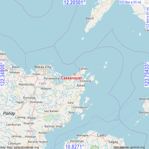
Cassanayan GPS coordinates[2]
11° 31' 0.84" North, 123° 3' 4.32" East
| Map corner | latitude | longitude |
|---|---|---|
| Upper-left | 12.20501°, | 122.34808° |
| Center: | 11.5169°, | 123.0512° |
| Lower-right: | 10.8271°, | 123.75433° |
| Map W x H: | 153.2×153.2 km | = 95.2×95.2mi |
| max Lat: | 20.78733° ⇑51.2% North |
| Cassanayan: | 11.5169° |
| min Lat: | ⇓48.8% South 4.65442° |
| min Long | Cassanayan | max Long |
| 117.04868° | 123.0512° | 126.58417° |
| W 54.2%⇐ | ⇒45.8% E |
Elevation
Elevation of Cassanayan is 6 m = 20 ft, and this is 81.9 m = 269 ft below average elevation for this country.
| Max E: |
2262 m = 7421 ft | 92.7% |
| Avg. | 87.9 m = 288 ft | |
| Cassanayan | 6 m = 20 ft | |
Min E: |
-2 m = -7 ft | 7.3% |
See also: Philippines elevation on elevation.city.
Geographical zone
Cassanayan is located in North Torrid zone (between Equator and Tropic of Cancer). Distance of Equator is 1280.6 km =795.7 mi to South.| Distance of | km | miles | from Cassanayan |
|---|---|---|---|
| North Pole | 8726.5 | 5422.4 | to North |
| Arctic Circle | 6120.6 | 3803.2 | to North |
| Tropic Cancer | 1325.4 | 823.6 | to North |
| Equator | 1280.6 | 795.7 | to South |


Nearby cities:
15 places around Cassanayan: (largest is in red/bold)
• Balasan
6.3 km =3.9 mi,  140°
140°
• Bancal
12.3 km =7.6 mi,  67°
67°
• Batad
12.6 km =7.8 mi,  150°
150°
• Bayas
17 km =10.6 mi,  123°
123°
• Binon-an
16.8 km =10.4 mi, 143°
• Cabilao
10.4 km =6.5 mi,  75°
75°
• Carles
11 km =6.8 mi,  55°
55°
• Dulangan
12.4 km =7.7 mi,  236°
236°
• Estancia
13 km =8.1 mi, 122°
• Guinticgan
9.5 km =5.9 mi, 56°
• Hipona
21.5 km =13.4 mi, 238°
• Pilar
6.8 km =4.2 mi, 240°
• President Roxas
16.5 km =10.3 mi,  234°
234°
• Rizal
22.2 km =13.8 mi,  249°
249°
• Tarong
8.9 km =5.5 mi, 79°
Sources, notices
• [Note1] Compared only with cities in Philippines existing in our database
• [Src1] Map data: © OpenStreetMap contributors (CC-BY-SA)
• [Src2] Other city data from geonames.org with taken over terms of usage.
• [Src3] Geographical zone / Annual Mean Temperature by Robert A. Rohde @ Wikipedia
