Bancal geodata
Bancal (Western Visayas) is a populated place; located in Philippines in Asia/Manila (GMT+8) time zone. With population of 4,295 people, there are 1589 cities with bigger population in this country. Compared to other cities in Philippines, 50.7% of cities are located further ↑North; 55.9% of cities are located further ←West and 65.1% of cities have higher elevation than Bancal. Note1


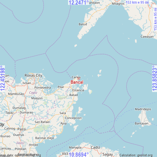
Bancal GPS coordinates[2]
11° 33' 32.76" North, 123° 9' 18.36" East
| Map corner | latitude | longitude |
|---|---|---|
| Upper-left | 12.2471°, | 122.45198° |
| Center: | 11.5591°, | 123.1551° |
| Lower-right: | 10.8694°, | 123.85823° |
| Map W x H: | 153.2×153.2 km | = 95.2×95.2mi |
| max Lat: | 20.78733° ⇑50.7% North |
| Bancal: | 11.5591° |
| min Lat: | ⇓49.3% South 4.65442° |
| min Long | Bancal | max Long |
| 117.04868° | 123.1551° | 126.58417° |
| W 55.9%⇐ | ⇒44.1% E |
Elevation
Elevation of Bancal is 14 m = 46 ft, and this is 73.9 m = 242 ft below average elevation for this country.
| Max E: |
2262 m = 7421 ft | 65.1% |
| Avg. | 87.9 m = 288 ft | |
| Bancal | 14 m = 46 ft | |
Min E: |
-2 m = -7 ft | 34.9% |
See also: Philippines elevation on elevation.city.
Geographical zone
Bancal is located in North Torrid zone (between Equator and Tropic of Cancer). Distance of Equator is 1285.3 km =798.6 mi to South.| Distance of | km | miles | from Bancal |
|---|---|---|---|
| North Pole | 8721.8 | 5419.5 | to North |
| Arctic Circle | 6115.9 | 3800.2 | to North |
| Tropic Cancer | 1320.7 | 820.6 | to North |
| Equator | 1285.3 | 798.6 | to South |


Nearby cities:
15 places around Bancal: (largest is in red/bold)
• Balasan
12.1 km =7.5 mi,  217°
217°
• Batad
16.5 km =10.3 mi,  198°
198°
• Bayas
14.2 km =8.8 mi,  168°
168°
• Binon-an
18.3 km =11.4 mi,  184°
184°
• Cabilao
2.5 km =1.6 mi,  210°
210°
• Carles
2.7 km =1.7 mi,  303°
303°
• Cassanayan
12.3 km =7.6 mi,  247°
247°
• Estancia
11.6 km =7.2 mi, 181°
• Gabi
20.3 km =12.6 mi,  78°
78°
• Granada
22.8 km =14.2 mi,  68°
68°
• Guinticgan
3.5 km =2.2 mi,  279°
279°
• Lantangan
18.9 km =11.7 mi, 80°
• Pilar
19.1 km =11.9 mi, 245°
• San Fernando
15.2 km =9.4 mi,  137°
137°
• Tarong
4 km =2.5 mi, 219°
Sources, notices
• [Note1] Compared only with cities in Philippines existing in our database
• [Src1] Map data: © OpenStreetMap contributors (CC-BY-SA)
• [Src2] Other city data from geonames.org with taken over terms of usage.
• [Src3] Geographical zone / Annual Mean Temperature by Robert A. Rohde @ Wikipedia
