Cartagena geodata
Cartagena (Western Visayas) is a populated place; located in Philippines in Asia/Manila (GMT+8) time zone. With population of 3,396 people, there are 2136 cities with bigger population in this country. Compared to other cities in Philippines, 70.1% of cities are located further ↑North; 56.1% of cities are located further →East and 89.7% of cities have higher elevation than Cartagena. Note1
Administrative division(s):
- Level 1: Western Visayas
- Level 2: Province of Negros Occidental
- Level 3: City of Sipalay


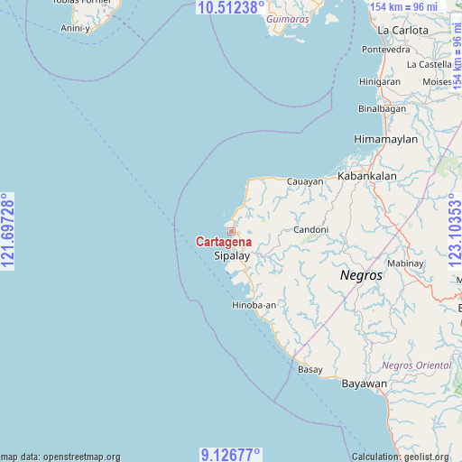
Cartagena GPS coordinates[2]
9° 49' 13.08" North, 122° 24' 1.44" East
| Map corner | latitude | longitude |
|---|---|---|
| Upper-left | 10.51238°, | 121.69728° |
| Center: | 9.8203°, | 122.4004° |
| Lower-right: | 9.12677°, | 123.10353° |
| Map W x H: | 154.1×154.1 km | = 95.8×95.8mi |
| max Lat: | 20.78733° ⇑70.1% North |
| Cartagena: | 9.8203° |
| min Lat: | ⇓29.9% South 4.65442° |
| min Long | Cartagena | max Long |
| 117.04868° | 122.4004° | 126.58417° |
| W 43.9%⇐ | ⇒56.1% E |
Elevation
Elevation of Cartagena is 7 m = 23 ft, and this is 80.9 m = 265 ft below average elevation for this country.
| Max E: |
2262 m = 7421 ft | 89.7% |
| Avg. | 87.9 m = 288 ft | |
| Cartagena | 7 m = 23 ft | |
Min E: |
-2 m = -7 ft | 10.3% |
See also: Philippines elevation on elevation.city.
Geographical zone
Cartagena is located in North Torrid zone (between Equator and Tropic of Cancer). Distance of Equator is 1091.9 km =678.5 mi to South.| Distance of | km | miles | from Cartagena |
|---|---|---|---|
| North Pole | 8915.1 | 5539.6 | to North |
| Arctic Circle | 6309.3 | 3920.4 | to North |
| Tropic Cancer | 1514 | 940.8 | to North |
| Equator | 1091.9 | 678.5 | to South |


Nearby cities:
15 places around Cartagena: (largest is in red/bold)
• Bacuyangan
21.8 km =13.5 mi,  158°
158°
• Bulata
4.4 km =2.7 mi,  1°
1°
• Cabadiangan
11 km =6.8 mi,  132°
132°
• Candoni
22.3 km =13.9 mi,  90°
90°
• Canturay
6.6 km =4.1 mi,  116°
116°
• Cayhagan
16.2 km =10.1 mi,  167°
167°
• Inayauan
9.6 km =6 mi,  22°
22°
• Kaliling
19.9 km =12.4 mi,  26°
26°
• Linaon
15.3 km =9.5 mi, 20°
• Manlucahoc
13.9 km =8.6 mi, 129°
• Maricalom
13 km =8.1 mi, 171°
• Masaling
23.4 km =14.5 mi,  39°
39°
• Nabulao
18.7 km =11.6 mi, 160°
• Sipalay
7.6 km =4.7 mi,  176°
176°
• Tuyum
24.5 km =15.2 mi, 44°
Sources, notices
• [Note1] Compared only with cities in Philippines existing in our database
• [Src1] Map data: © OpenStreetMap contributors (CC-BY-SA)
• [Src2] Other city data from geonames.org with taken over terms of usage.
• [Src3] Geographical zone / Annual Mean Temperature by Robert A. Rohde @ Wikipedia
