Candijay geodata
Candijay (Central Visayas) is a seat of a third-order administrative division; located in Philippines in Asia/Manila (GMT+8) time zone. With population of 4,125 people, there are 1653 cities with bigger population in this country. Compared to other cities in Philippines, 70.1% of cities are located further ↑North; 78.8% of cities are located further ←West and 65.1% of cities have higher elevation than Candijay. Note1


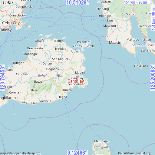
Candijay GPS coordinates[2]
9° 49' 5.52" North, 124° 29' 51.72" East
| Map corner | latitude | longitude |
|---|---|---|
| Upper-left | 10.51029°, | 123.79458° |
| Center: | 9.8182°, | 124.4977° |
| Lower-right: | 9.12466°, | 125.20083° |
| Map W x H: | 154.1×154.1 km | = 95.8×95.8mi |
| max Lat: | 20.78733° ⇑70.1% North |
| Candijay: | 9.8182° |
| min Lat: | ⇓29.9% South 4.65442° |
| min Long | Candijay | max Long |
| 117.04868° | 124.4977° | 126.58417° |
| W 78.8%⇐ | ⇒21.2% E |
Elevation
Elevation of Candijay is 14 m = 46 ft, and this is 73.9 m = 242 ft below average elevation for this country.
| Max E: |
2262 m = 7421 ft | 65.1% |
| Avg. | 87.9 m = 288 ft | |
| Candijay | 14 m = 46 ft | |
Min E: |
-2 m = -7 ft | 34.9% |
See also: Philippines elevation on elevation.city.
Geographical zone
Candijay is located in North Torrid zone (between Equator and Tropic of Cancer). Distance of Equator is 1091.7 km =678.4 mi to South.| Distance of | km | miles | from Candijay |
|---|---|---|---|
| North Pole | 8915.4 | 5539.8 | to North |
| Arctic Circle | 6309.5 | 3920.5 | to North |
| Tropic Cancer | 1514.2 | 940.9 | to North |
| Equator | 1091.7 | 678.4 | to South |


Nearby cities:
15 places around Candijay: (largest is in red/bold)
• Abaca
11.4 km =7.1 mi,  4°
4°
• Alicia
10.5 km =6.5 mi,  324°
324°
• Anda
11.8 km =7.3 mi,  132°
132°
• Bacong
11.5 km =7.1 mi,  139°
139°
• Biabas
4 km =2.5 mi,  239°
239°
• Candabong
10.3 km =6.4 mi,  154°
154°
• Canhaway
8.1 km =5 mi,  200°
200°
• Catungawan Sur
5.1 km =3.2 mi,  217°
217°
• Cogtong
4 km =2.5 mi,  58°
58°
• Duero
15.8 km =9.8 mi, 219°
• Giawang
3.1 km =1.9 mi,  156°
156°
• Guindulman
6.2 km =3.9 mi,  190°
190°
• La Hacienda
13.5 km =8.4 mi,  301°
301°
• Lombog
9.8 km =6.1 mi, 243°
• Mabini
5.8 km =3.6 mi,  26°
26°
Sources, notices
• [Note1] Compared only with cities in Philippines existing in our database
• [Src1] Map data: © OpenStreetMap contributors (CC-BY-SA)
• [Src2] Other city data from geonames.org with taken over terms of usage.
• [Src3] Geographical zone / Annual Mean Temperature by Robert A. Rohde @ Wikipedia
