Abaca geodata
Abaca (Central Visayas) is a populated place; located in Philippines in Asia/Manila (GMT+8) time zone. With population of 2,480 people, there are 3329 cities with bigger population in this country. Compared to other cities in Philippines, 69.1% of cities are located further ↑North; 79% of cities are located further ←West and 68.5% of cities have lower elevation than Abaca. Note1


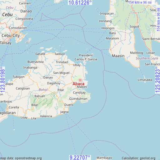
Abaca GPS coordinates[2]
9° 55' 13.44" North, 124° 30' 18.36" East
| Map corner | latitude | longitude |
|---|---|---|
| Upper-left | 10.61226°, | 123.80198° |
| Center: | 9.9204°, | 124.5051° |
| Lower-right: | 9.22707°, | 125.20823° |
| Map W x H: | 154×154 km | = 95.7×95.7mi |
| max Lat: | 20.78733° ⇑69.1% North |
| Abaca: | 9.9204° |
| min Lat: | ⇓30.9% South 4.65442° |
| min Long | Abaca | max Long |
| 117.04868° | 124.5051° | 126.58417° |
| W 79%⇐ | ⇒21% E |
Elevation
Elevation of Abaca is 49 m = 161 ft, and this is 38.9 m = 128 ft below average elevation for this country.
| Max E: |
2262 m = 7421 ft | 31.5% |
| Avg. | 87.9 m = 288 ft | |
| Abaca | 49 m = 161 ft | |
Min E: |
-2 m = -7 ft | 68.5% |
See also: Philippines elevation on elevation.city.
Geographical zone
Abaca is located in North Torrid zone (between Equator and Tropic of Cancer). Distance of Equator is 1103 km =685.4 mi to South.| Distance of | km | miles | from Abaca |
|---|---|---|---|
| North Pole | 8904 | 5532.7 | to North |
| Arctic Circle | 6298.1 | 3913.5 | to North |
| Tropic Cancer | 1502.9 | 933.9 | to North |
| Equator | 1103 | 685.4 | to South |


Nearby cities:
15 places around Abaca: (largest is in red/bold)
• Alicia
7.5 km =4.7 mi,  247°
247°
• Biabas
14 km =8.7 mi,  197°
197°
• Camambugan
17 km =10.6 mi,  334°
334°
• Candijay
11.4 km =7.1 mi,  184°
184°
• Catungawan Sur
15.9 km =9.9 mi,  194°
194°
• Cogtong
9.6 km =6 mi,  164°
164°
• Giawang
14.3 km =8.9 mi, 178°
• Guindulman
17.6 km =10.9 mi, 186°
• La Hacienda
13.1 km =8.1 mi, 250°
• Lombog
18.4 km =11.4 mi,  211°
211°
• Mabini
6.4 km =4 mi, 163°
• San Pascual
9.2 km =5.7 mi,  293°
293°
• Tipolo
11.1 km =6.9 mi,  5°
5°
• Ubay
15.5 km =9.6 mi,  346°
346°
• Union
14.2 km =8.8 mi,  4°
4°
Sources, notices
• [Note1] Compared only with cities in Philippines existing in our database
• [Src1] Map data: © OpenStreetMap contributors (CC-BY-SA)
• [Src2] Other city data from geonames.org with taken over terms of usage.
• [Src3] Geographical zone / Annual Mean Temperature by Robert A. Rohde @ Wikipedia
