Mabini geodata
Mabini (Central Visayas) is a seat of a third-order administrative division; located in Philippines in Asia/Manila (GMT+8) time zone. With population of 5,999 people, there are 1046 cities with bigger population in this country. Compared to other cities in Philippines, 69.7% of cities are located further ↑North; 79.2% of cities are located further ←West and 65.1% of cities have higher elevation than Mabini. Note1


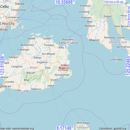
Mabini GPS coordinates[2]
9° 51' 53.64" North, 124° 31' 17.4" East
| Map corner | latitude | longitude |
|---|---|---|
| Upper-left | 10.55688°, | 123.81838° |
| Center: | 9.8649°, | 124.5215° |
| Lower-right: | 9.17146°, | 125.22463° |
| Map W x H: | 154×154 km | = 95.7×95.7mi |
| max Lat: | 20.78733° ⇑69.7% North |
| Mabini: | 9.8649° |
| min Lat: | ⇓30.3% South 4.65442° |
| min Long | Mabini | max Long |
| 117.04868° | 124.5215° | 126.58417° |
| W 79.2%⇐ | ⇒20.8% E |
Elevation
Elevation of Mabini is 14 m = 46 ft, and this is 73.9 m = 242 ft below average elevation for this country.
| Max E: |
2262 m = 7421 ft | 65.1% |
| Avg. | 87.9 m = 288 ft | |
| Mabini | 14 m = 46 ft | |
Min E: |
-2 m = -7 ft | 34.9% |
See also: Philippines elevation on elevation.city.
Geographical zone
Mabini is located in North Torrid zone (between Equator and Tropic of Cancer). Distance of Equator is 1096.9 km =681.6 mi to South.| Distance of | km | miles | from Mabini |
|---|---|---|---|
| North Pole | 8910.2 | 5536.5 | to North |
| Arctic Circle | 6304.3 | 3917.3 | to North |
| Tropic Cancer | 1509 | 937.6 | to North |
| Equator | 1096.9 | 681.6 | to South |


Nearby cities:
15 places around Mabini: (largest is in red/bold)
• Abaca
6.4 km =4 mi,  343°
343°
• Alicia
9.3 km =5.8 mi,  291°
291°
• Anda
14.5 km =9 mi,  155°
155°
• Bacong
14.8 km =9.2 mi, 160°
• Biabas
9.4 km =5.8 mi,  219°
219°
• Candabong
14.6 km =9.1 mi,  172°
172°
• Candijay
5.8 km =3.6 mi,  206°
206°
• Canhaway
13.9 km =8.6 mi,  202°
202°
• Catungawan Sur
10.9 km =6.8 mi, 211°
• Cogtong
3.2 km =2 mi, 164°
• Giawang
8.2 km =5.1 mi,  189°
189°
• Guindulman
11.9 km =7.4 mi, 198°
• La Hacienda
14.3 km =8.9 mi,  277°
277°
• Lombog
14.9 km =9.3 mi,  229°
229°
• San Pascual
14.2 km =8.8 mi,  314°
314°
Sources, notices
• [Note1] Compared only with cities in Philippines existing in our database
• [Src1] Map data: © OpenStreetMap contributors (CC-BY-SA)
• [Src2] Other city data from geonames.org with taken over terms of usage.
• [Src3] Geographical zone / Annual Mean Temperature by Robert A. Rohde @ Wikipedia
