Calingcuan geodata
Calingcuan (Central Luzon) is a populated place; located in Philippines in Asia/Manila (GMT+8) time zone. With population of 3,208 people, there are 2296 cities with bigger population in this country. Compared to other cities in Philippines, 80.2% of cities are located further ↓South; 88.7% of cities are located further →East and 68.5% of cities have lower elevation than Calingcuan. Note1


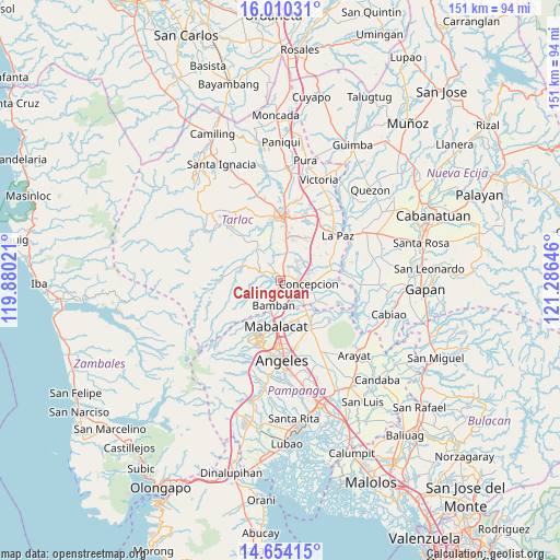
Calingcuan GPS coordinates[2]
15° 19' 59.988" North, 120° 34' 59.988" East
| Map corner | latitude | longitude |
|---|---|---|
| Upper-left | 16.01031°, | 119.88021° |
| Center: | 15.33333°, | 120.58333° |
| Lower-right: | 14.65415°, | 121.28646° |
| Map W x H: | 150.8×150.8 km | = 93.7×93.7mi |
| max Lat: | 20.78733° ⇑19.8% North |
| Calingcuan: | 15.33333° |
| min Lat: | ⇓80.2% South 4.65442° |
| min Long | Calingcuan | max Long |
| 117.04868° | 120.58333° | 126.58417° |
| W 11.3%⇐ | ⇒88.7% E |
Elevation
Elevation of Calingcuan is 49 m = 161 ft, and this is 38.9 m = 128 ft below average elevation for this country.
| Max E: |
2262 m = 7421 ft | 31.5% |
| Avg. | 87.9 m = 288 ft | |
| Calingcuan | 49 m = 161 ft | |
Min E: |
-2 m = -7 ft | 68.5% |
See also: Philippines elevation on elevation.city.
Geographical zone
Calingcuan is located in North Torrid zone (between Equator and Tropic of Cancer). Distance of this Northern Tropic circle is 901 km =559.9 mi to North.| Distance of | km | miles | from Calingcuan |
|---|---|---|---|
| North Pole | 8302.2 | 5158.7 | to North |
| Arctic Circle | 5696.3 | 3539.5 | to North |
| Tropic Cancer | 901 | 559.9 | to North |
| Equator | 1704.9 | 1059.4 | to South |


Nearby cities:
15 places around Calingcuan: (largest is in red/bold)
• Arminia
11.6 km =7.2 mi,  349°
349°
• Balutu
12.3 km =7.6 mi,  108°
108°
• Capas
0.7 km =0.4 mi, 109°
• Concepcion
8 km =5 mi,  96°
96°
• Mabilog
11.2 km =7 mi,  52°
52°
• Murcia
8.4 km =5.2 mi,  19°
19°
• San Antonio
10.8 km =6.7 mi,  118°
118°
• San Roque
10.9 km =6.8 mi,  137°
137°
• San Vicente
8.9 km =5.5 mi, 120°
• Santa Lucia
11.1 km =6.9 mi,  290°
290°
• Santa Rosa
5.2 km =3.2 mi,  43°
43°
• Santo Cristo
1.2 km =0.7 mi,  62°
62°
• Santo Niño
4.6 km =2.9 mi,  88°
88°
• Talaga
5.7 km =3.5 mi,  6°
6°
• Tinang
8.9 km =5.5 mi, 57°
Sources, notices
• [Note1] Compared only with cities in Philippines existing in our database
• [Src1] Map data: © OpenStreetMap contributors (CC-BY-SA)
• [Src2] Other city data from geonames.org with taken over terms of usage.
• [Src3] Geographical zone / Annual Mean Temperature by Robert A. Rohde @ Wikipedia
