Mabilog geodata
Mabilog (Central Luzon) is a populated place; located in Philippines in Asia/Manila (GMT+8) time zone. With population of 2,581 people, there are 3141 cities with bigger population in this country. Compared to other cities in Philippines, 80.7% of cities are located further ↓South; 85.9% of cities are located further →East and 62.2% of cities have lower elevation than Mabilog. Note1


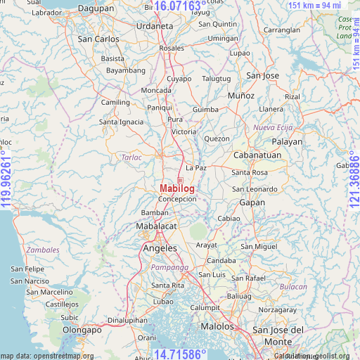
Mabilog GPS coordinates[2]
15° 23' 41.46" North, 120° 39' 56.628" East
| Map corner | latitude | longitude |
|---|---|---|
| Upper-left | 16.07163°, | 119.96261° |
| Center: | 15.39485°, | 120.66573° |
| Lower-right: | 14.71586°, | 121.36886° |
| Map W x H: | 150.7×150.7 km | = 93.6×93.6mi |
| max Lat: | 20.78733° ⇑19.3% North |
| Mabilog: | 15.39485° |
| min Lat: | ⇓80.7% South 4.65442° |
| min Long | Mabilog | max Long |
| 117.04868° | 120.66573° | 126.58417° |
| W 14.1%⇐ | ⇒85.9% E |
Elevation
Elevation of Mabilog is 37 m = 121 ft, and this is 50.9 m = 167 ft below average elevation for this country.
| Max E: |
2262 m = 7421 ft | 37.8% |
| Avg. | 87.9 m = 288 ft | |
| Mabilog | 37 m = 121 ft | |
Min E: |
-2 m = -7 ft | 62.2% |
See also: Philippines elevation on elevation.city.
Geographical zone
Mabilog is located in North Torrid zone (between Equator and Tropic of Cancer). Distance of this Northern Tropic circle is 894.2 km =555.6 mi to North.| Distance of | km | miles | from Mabilog |
|---|---|---|---|
| North Pole | 8295.3 | 5154.5 | to North |
| Arctic Circle | 5689.4 | 3535.2 | to North |
| Tropic Cancer | 894.2 | 555.6 | to North |
| Equator | 1711.7 | 1063.6 | to South |


Nearby cities:
15 places around Mabilog: (largest is in red/bold)
• Amucao
8 km =5 mi,  16°
16°
• Cafe
7.8 km =4.8 mi,  146°
146°
• Comillas
3.7 km =2.3 mi,  84°
84°
• Concepcion
7.8 km =4.8 mi,  186°
186°
• Dumarais
5.2 km =3.2 mi,  32°
32°
• Mapalacsiao
4 km =2.5 mi,  339°
339°
• Motrico
2.4 km =1.5 mi, 29°
• Murcia
6.2 km =3.9 mi,  279°
279°
• Pando
2 km =1.2 mi,  92°
92°
• San Isidro
8.3 km =5.2 mi,  50°
50°
• Santa Monica
7.1 km =4.4 mi,  125°
125°
• Santa Rosa
6 km =3.7 mi,  239°
239°
• Santo Niño
8 km =5 mi,  212°
212°
• Talaga
8.3 km =5.2 mi,  261°
261°
• Tinang
2.5 km =1.6 mi, 212°
Sources, notices
• [Note1] Compared only with cities in Philippines existing in our database
• [Src1] Map data: © OpenStreetMap contributors (CC-BY-SA)
• [Src2] Other city data from geonames.org with taken over terms of usage.
• [Src3] Geographical zone / Annual Mean Temperature by Robert A. Rohde @ Wikipedia
