Cagamotan geodata
Cagamotan (Eastern Visayas) is a populated place; located in Philippines in Asia/Manila (GMT+8) time zone. With population of 2,688 people, there are 2969 cities with bigger population in this country. Compared to other cities in Philippines, 53.8% of cities are located further ↓South; 91.2% of cities are located further ←West and 80.7% of cities have higher elevation than Cagamotan. Note1
Administrative division(s):
- Level 1: Eastern Visayas
- Level 2: Province of Northern Samar
- Level 3: Gamay


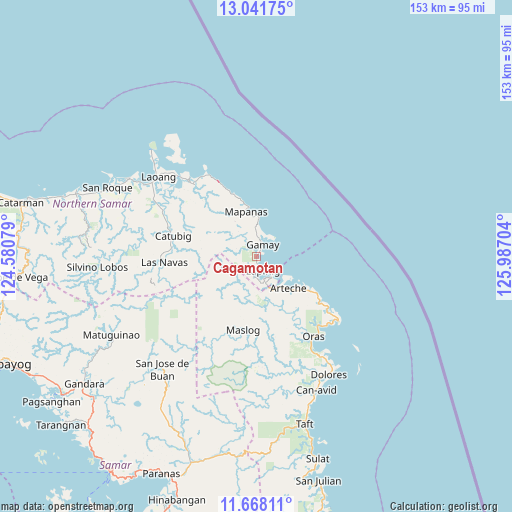
Cagamotan GPS coordinates[2]
12° 21' 20.988" North, 125° 17' 2.076" East
| Map corner | latitude | longitude |
|---|---|---|
| Upper-left | 13.04175°, | 124.58079° |
| Center: | 12.35583°, | 125.28391° |
| Lower-right: | 11.66811°, | 125.98704° |
| Map W x H: | 152.7×152.7 km | = 94.9×94.9mi |
| max Lat: | 20.78733° ⇑46.2% North |
| Cagamotan: | 12.35583° |
| min Lat: | ⇓53.8% South 4.65442° |
| min Long | Cagamotan | max Long |
| 117.04868° | 125.28391° | 126.58417° |
| W 91.2%⇐ | ⇒8.8% E |
Elevation
Elevation of Cagamotan is 9 m = 30 ft, and this is 78.9 m = 259 ft below average elevation for this country.
| Max E: |
2262 m = 7421 ft | 80.7% |
| Avg. | 87.9 m = 288 ft | |
| Cagamotan | 9 m = 30 ft | |
Min E: |
-2 m = -7 ft | 19.3% |
See also: Philippines elevation on elevation.city.
Geographical zone
Cagamotan is located in North Torrid zone (between Equator and Tropic of Cancer). Distance of this Northern Tropic circle is 1232.1 km =765.6 mi to North.| Distance of | km | miles | from Cagamotan |
|---|---|---|---|
| North Pole | 8633.2 | 5364.4 | to North |
| Arctic Circle | 6027.3 | 3745.2 | to North |
| Tropic Cancer | 1232.1 | 765.6 | to North |
| Equator | 1373.8 | 853.6 | to South |


Nearby cities:
15 places around Cagamotan: (largest is in red/bold)
• Alugan
26.3 km =16.3 mi,  125°
125°
• Anito
10.5 km =6.5 mi,  2°
2°
• Arteche
16.6 km =10.3 mi, 127°
• Cabatuan
19.8 km =12.3 mi,  339°
339°
• Catubig
25.6 km =15.9 mi,  283°
283°
• Gamay
3.6 km =2.2 mi,  24°
24°
• Hipadpad
9.4 km =5.8 mi,  213°
213°
• Lapinig
5 km =3.1 mi,  155°
155°
• Las Navas
27.5 km =17.1 mi,  266°
266°
• Mapanas
13.6 km =8.5 mi,  347°
347°
• Maslog
23.5 km =14.6 mi,  193°
193°
• Oras
29.3 km =18.2 mi,  144°
144°
• Palapag
28 km =17.4 mi,  318°
318°
• Patong
2.2 km =1.4 mi,  176°
176°
• San Eduardo
27.6 km =17.1 mi, 139°
Sources, notices
• [Note1] Compared only with cities in Philippines existing in our database
• [Src1] Map data: © OpenStreetMap contributors (CC-BY-SA)
• [Src2] Other city data from geonames.org with taken over terms of usage.
• [Src3] Geographical zone / Annual Mean Temperature by Robert A. Rohde @ Wikipedia
