Gamay geodata
Gamay (Eastern Visayas) is a seat of a third-order administrative division; located in Philippines in Asia/Manila (GMT+8) time zone. With population of 9,125 people, there are 675 cities with bigger population in this country. Compared to other cities in Philippines, 54% of cities are located further ↓South; 91.4% of cities are located further ←West and 85.4% of cities have higher elevation than Gamay. Note1
Administrative division(s):
- Level 1: Eastern Visayas
- Level 2: Province of Northern Samar
- Level 3: Gamay


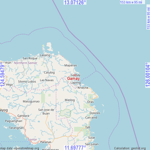
Gamay GPS coordinates[2]
12° 23' 7.512" North, 125° 17' 52.476" East
| Map corner | latitude | longitude |
|---|---|---|
| Upper-left | 13.07126°, | 124.59479° |
| Center: | 12.38542°, | 125.29791° |
| Lower-right: | 11.69777°, | 126.00104° |
| Map W x H: | 152.7×152.7 km | = 94.9×94.9mi |
| max Lat: | 20.78733° ⇑46% North |
| Gamay: | 12.38542° |
| min Lat: | ⇓54% South 4.65442° |
| min Long | Gamay | max Long |
| 117.04868° | 125.29791° | 126.58417° |
| W 91.4%⇐ | ⇒8.6% E |
Elevation
Elevation of Gamay is 8 m = 26 ft, and this is 79.9 m = 262 ft below average elevation for this country.
| Max E: |
2262 m = 7421 ft | 85.4% |
| Avg. | 87.9 m = 288 ft | |
| Gamay | 8 m = 26 ft | |
Min E: |
-2 m = -7 ft | 14.6% |
See also: Philippines elevation on elevation.city.
Geographical zone
Gamay is located in North Torrid zone (between Equator and Tropic of Cancer). Distance of this Northern Tropic circle is 1228.8 km =763.5 mi to North.| Distance of | km | miles | from Gamay |
|---|---|---|---|
| North Pole | 8629.9 | 5362.4 | to North |
| Arctic Circle | 6024 | 3743.1 | to North |
| Tropic Cancer | 1228.8 | 763.5 | to North |
| Equator | 1377.1 | 855.7 | to South |


Nearby cities:
15 places around Gamay: (largest is in red/bold)
• Alugan
27.2 km =16.9 mi,  132°
132°
• Anito
7.2 km =4.5 mi,  351°
351°
• Arteche
17.8 km =11.1 mi,  139°
139°
• Cabatuan
17.5 km =10.9 mi,  331°
331°
• Cagamotan
3.6 km =2.2 mi,  204°
204°
• Catubig
26.5 km =16.5 mi,  275°
275°
• Hipadpad
13 km =8.1 mi,  211°
211°
• Lapinig
7.8 km =4.8 mi,  175°
175°
• Las Navas
29.4 km =18.3 mi,  259°
259°
• Mapanas
10.9 km =6.8 mi,  335°
335°
• Maslog
27.1 km =16.8 mi, 195°
• Palapag
26.7 km =16.6 mi,  311°
311°
• Patong
5.6 km =3.5 mi,  194°
194°
• San Eduardo
29.3 km =18.2 mi,  145°
145°
• Viga
30.3 km =18.8 mi,  298°
298°
Sources, notices
• [Note1] Compared only with cities in Philippines existing in our database
• [Src1] Map data: © OpenStreetMap contributors (CC-BY-SA)
• [Src2] Other city data from geonames.org with taken over terms of usage.
• [Src3] Geographical zone / Annual Mean Temperature by Robert A. Rohde @ Wikipedia
