Busay geodata
Busay (Western Visayas) is a populated place; located in Philippines in Asia/Manila (GMT+8) time zone. With population of 5,503 people, there are 1156 cities with bigger population in this country. Compared to other cities in Philippines, 62.7% of cities are located further ↑North; 51.3% of cities are located further ←West and 70.2% of cities have higher elevation than Busay. Note1
Administrative division(s):
- Level 1: Western Visayas
- Level 2: Province of Negros Occidental
- Level 3: Bago City


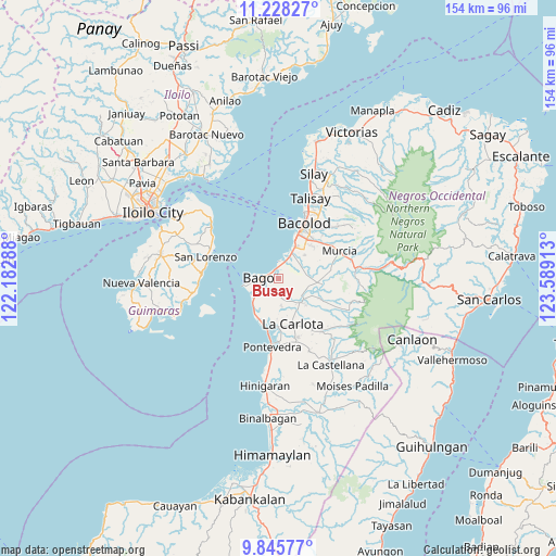
Busay GPS coordinates[2]
10° 32' 16.08" North, 122° 53' 9.6" East
| Map corner | latitude | longitude |
|---|---|---|
| Upper-left | 11.22827°, | 122.18288° |
| Center: | 10.5378°, | 122.886° |
| Lower-right: | 9.84577°, | 123.58913° |
| Map W x H: | 153.7×153.7 km | = 95.5×95.5mi |
| max Lat: | 20.78733° ⇑62.7% North |
| Busay: | 10.5378° |
| min Lat: | ⇓37.3% South 4.65442° |
| min Long | Busay | max Long |
| 117.04868° | 122.886° | 126.58417° |
| W 51.3%⇐ | ⇒48.7% E |
Elevation
Elevation of Busay is 12 m = 39 ft, and this is 75.9 m = 249 ft below average elevation for this country.
| Max E: |
2262 m = 7421 ft | 70.2% |
| Avg. | 87.9 m = 288 ft | |
| Busay | 12 m = 39 ft | |
Min E: |
-2 m = -7 ft | 29.8% |
See also: Philippines elevation on elevation.city.
Geographical zone
Busay is located in North Torrid zone (between Equator and Tropic of Cancer). Distance of Equator is 1171.7 km =728.1 mi to South.| Distance of | km | miles | from Busay |
|---|---|---|---|
| North Pole | 8835.4 | 5490.1 | to North |
| Arctic Circle | 6229.5 | 3870.8 | to North |
| Tropic Cancer | 1434.2 | 891.2 | to North |
| Equator | 1171.7 | 728.1 | to South |


Nearby cities:
15 places around Busay: (largest is in red/bold)
• Alijis
10.5 km =6.5 mi,  212°
212°
• Atipuluhan
8.8 km =5.5 mi,  108°
108°
• Bago City
5.8 km =3.6 mi,  265°
265°
• Bagumbayan
11.6 km =7.2 mi, 208°
• Banga
7.4 km =4.6 mi,  237°
237°
• Caridad
4.7 km =2.9 mi,  164°
164°
• Dulao
5.7 km =3.5 mi,  85°
85°
• Himaya
11.2 km =7 mi, 211°
• Napoles
4 km =2.5 mi, 160°
• Pacol
12.4 km =7.7 mi,  217°
217°
• Pulupandan
9.4 km =5.8 mi,  258°
258°
• Sagasa
7.8 km =4.8 mi,  173°
173°
• Sumag
7.9 km =4.9 mi,  27°
27°
• Taloc
4.2 km =2.6 mi,  14°
14°
• Valladolid
10.8 km =6.7 mi, 218°
Sources, notices
• [Note1] Compared only with cities in Philippines existing in our database
• [Src1] Map data: © OpenStreetMap contributors (CC-BY-SA)
• [Src2] Other city data from geonames.org with taken over terms of usage.
• [Src3] Geographical zone / Annual Mean Temperature by Robert A. Rohde @ Wikipedia
