Dulao geodata
Dulao (Western Visayas) is a populated place; located in Philippines in Asia/Manila (GMT+8) time zone. With population of 7,403 people, there are 841 cities with bigger population in this country. Compared to other cities in Philippines, 62.7% of cities are located further ↑North; 52.2% of cities are located further ←West and 54.4% of cities have lower elevation than Dulao. Note1
Administrative division(s):
- Level 1: Western Visayas
- Level 2: Province of Negros Occidental
- Level 3: Bago City


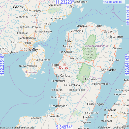
Dulao GPS coordinates[2]
10° 32' 30.336" North, 122° 56' 17.88" East
| Map corner | latitude | longitude |
|---|---|---|
| Upper-left | 11.23223°, | 122.23518° |
| Center: | 10.54176°, | 122.9383° |
| Lower-right: | 9.84974°, | 123.64143° |
| Map W x H: | 153.7×153.7 km | = 95.5×95.5mi |
| max Lat: | 20.78733° ⇑62.7% North |
| Dulao: | 10.54176° |
| min Lat: | ⇓37.3% South 4.65442° |
| min Long | Dulao | max Long |
| 117.04868° | 122.9383° | 126.58417° |
| W 52.2%⇐ | ⇒47.8% E |
Elevation
Elevation of Dulao is 27 m = 89 ft, and this is 60.9 m = 200 ft below average elevation for this country.
| Max E: |
2262 m = 7421 ft | 45.6% |
| Avg. | 87.9 m = 288 ft | |
| Dulao | 27 m = 89 ft | |
Min E: |
-2 m = -7 ft | 54.4% |
See also: Philippines elevation on elevation.city.
Geographical zone
Dulao is located in North Torrid zone (between Equator and Tropic of Cancer). Distance of Equator is 1172.1 km =728.3 mi to South.| Distance of | km | miles | from Dulao |
|---|---|---|---|
| North Pole | 8834.9 | 5489.8 | to North |
| Arctic Circle | 6229 | 3870.5 | to North |
| Tropic Cancer | 1433.8 | 890.9 | to North |
| Equator | 1172.1 | 728.3 | to South |


Nearby cities:
15 places around Dulao: (largest is in red/bold)
• Atipuluhan
4.1 km =2.5 mi,  140°
140°
• Bacolod City
13.9 km =8.6 mi,  5°
5°
• Bago City
11.5 km =7.1 mi,  265°
265°
• Banga
12.8 km =8 mi,  249°
249°
• Busay
5.7 km =3.5 mi, 265°
• Cansilayan
9 km =5.6 mi,  77°
77°
• Caridad
6.7 km =4.2 mi,  221°
221°
• La Carlota
13.2 km =8.2 mi,  188°
188°
• Maao
8.2 km =5.1 mi, 135°
• Mansilingan
10.9 km =6.8 mi,  24°
24°
• Murcia
13.3 km =8.3 mi,  58°
58°
• Napoles
6.1 km =3.8 mi,  226°
226°
• Sagasa
9.5 km =5.9 mi,  210°
210°
• Sumag
6.9 km =4.3 mi,  342°
342°
• Taloc
5.9 km =3.7 mi,  307°
307°
Sources, notices
• [Note1] Compared only with cities in Philippines existing in our database
• [Src1] Map data: © OpenStreetMap contributors (CC-BY-SA)
• [Src2] Other city data from geonames.org with taken over terms of usage.
• [Src3] Geographical zone / Annual Mean Temperature by Robert A. Rohde @ Wikipedia
