Taloc geodata
Taloc (Western Visayas) is a populated place; located in Philippines in Asia/Manila (GMT+8) time zone. With population of 20,409 people, there are 365 cities with bigger population in this country. Compared to other cities in Philippines, 62.3% of cities are located further ↑North; 51.5% of cities are located further ←West and 85.4% of cities have higher elevation than Taloc. Note1
Administrative division(s):
- Level 1: Western Visayas
- Level 2: Province of Negros Occidental
- Level 3: Bago City


Taloc GPS coordinates[2]
10° 34' 28.56" North, 122° 53' 43.44" East
| Map corner | latitude | longitude |
|---|---|---|
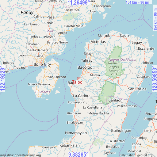
| Upper-left | 11.26499°, | 122.19228° |
| Center: | 10.5746°, | 122.8954° |
| Lower-right: | 9.88265°, | 123.59853° |
| Map W x H: | 153.7×153.7 km | = 95.5×95.5mi |
| max Lat: | 20.78733° ⇑62.3% North |
| Taloc: | 10.5746° |
| min Lat: | ⇓37.7% South 4.65442° |
| min Long | Taloc | max Long |
| 117.04868° | 122.8954° | 126.58417° |
| W 51.5%⇐ | ⇒48.5% E |
Elevation
Elevation of Taloc is 8 m = 26 ft, and this is 79.9 m = 262 ft below average elevation for this country.
| Max E: |
2262 m = 7421 ft | 85.4% |
| Avg. | 87.9 m = 288 ft | |
| Taloc | 8 m = 26 ft | |
Min E: |
-2 m = -7 ft | 14.6% |
See also: Philippines elevation on elevation.city.
Geographical zone
Taloc is located in North Torrid zone (between Equator and Tropic of Cancer). Distance of Equator is 1175.8 km =730.6 mi to South.| Distance of | km | miles | from Taloc |
|---|---|---|---|
| North Pole | 8831.3 | 5487.5 | to North |
| Arctic Circle | 6225.4 | 3868.3 | to North |
| Tropic Cancer | 1430.1 | 888.6 | to North |
| Equator | 1175.8 | 730.6 | to South |


Nearby cities:
15 places around Taloc: (largest is in red/bold)
• Alijis
14.5 km =9 mi,  207°
207°
• Atipuluhan
10 km =6.2 mi,  133°
133°
• Bacolod City
11.8 km =7.3 mi,  30°
30°
• Bago City
8.2 km =5.1 mi,  235°
235°
• Banga
10.9 km =6.8 mi,  221°
221°
• Busay
4.2 km =2.6 mi,  194°
194°
• Cansilayan
13.5 km =8.4 mi,  96°
96°
• Caridad
8.7 km =5.4 mi,  178°
178°
• Dulao
5.9 km =3.7 mi, 127°
• Maao
14.1 km =8.8 mi, 132°
• Mansilingan
11.1 km =6.9 mi,  55°
55°
• Napoles
7.9 km =4.9 mi, 178°
• Pulupandan
11.9 km =7.4 mi, 239°
• Sagasa
11.9 km =7.4 mi, 180°
• Sumag
4 km =2.5 mi,  41°
41°
Sources, notices
• [Note1] Compared only with cities in Philippines existing in our database
• [Src1] Map data: © OpenStreetMap contributors (CC-BY-SA)
• [Src2] Other city data from geonames.org with taken over terms of usage.
• [Src3] Geographical zone / Annual Mean Temperature by Robert A. Rohde @ Wikipedia
