Bolila geodata
Bolila (Davao) is a populated place; located in Philippines in Asia/Manila (GMT+8) time zone. With population of 2,125 people, there are 4038 cities with bigger population in this country. Compared to other cities in Philippines, 96.4% of cities are located further ↑North; 94.2% of cities are located further ←West and 75.3% of cities have lower elevation than Bolila. Note1


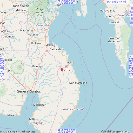
Bolila GPS coordinates[2]
6° 22' 18.012" North, 125° 34' 17.004" East
| Map corner | latitude | longitude |
|---|---|---|
| Upper-left | 7.06996°, | 124.86827° |
| Center: | 6.37167°, | 125.57139° |
| Lower-right: | 5.67243°, | 126.27452° |
| Map W x H: | 155.4×155.4 km | = 96.6×96.6mi |
| max Lat: | 20.78733° ⇑96.4% North |
| Bolila: | 6.37167° |
| min Lat: | ⇓3.6% South 4.65442° |
| min Long | Bolila | max Long |
| 117.04868° | 125.57139° | 126.58417° |
| W 94.2%⇐ | ⇒5.8% E |
Elevation
Elevation of Bolila is 69 m = 226 ft, and this is 18.9 m = 62 ft below average elevation for this country.
| Max E: |
2262 m = 7421 ft | 24.7% |
| Avg. | 87.9 m = 288 ft | |
| Bolila | 69 m = 226 ft | |
Min E: |
-2 m = -7 ft | 75.3% |
See also: Philippines elevation on elevation.city.
Geographical zone
Bolila is located in North Torrid zone (between Equator and Tropic of Cancer). Distance of Equator is 708.5 km =440.2 mi to South.| Distance of | km | miles | from Bolila |
|---|---|---|---|
| North Pole | 9298.6 | 5777.9 | to North |
| Arctic Circle | 6692.7 | 4158.6 | to North |
| Tropic Cancer | 1897.5 | 1179.1 | to North |
| Equator | 708.5 | 440.2 | to South |


Nearby cities:
15 places around Bolila: (largest is in red/bold)
• Basiawan
20.3 km =12.6 mi,  332°
332°
• Buhangin
13.5 km =8.4 mi,  348°
348°
• Bulacan
27.4 km =17 mi,  322°
322°
• Kinangan
8 km =5 mi,  169°
169°
• Lacaron
8.6 km =5.3 mi,  5°
5°
• Lais
9.3 km =5.8 mi,  117°
117°
• Lapuan
29 km =18 mi,  150°
150°
• Malita
6.6 km =4.1 mi,  42°
42°
• Manga
30.4 km =18.9 mi,  252°
252°
• Pangian
10.5 km =6.5 mi,  344°
344°
• Pung-Pang
18.4 km =11.4 mi, 319°
• Santa Maria
23.1 km =14.4 mi, 331°
• Talagutong
16 km =9.9 mi,  138°
138°
• Tanlad
29.2 km =18.1 mi, 331°
• Tubalan
13.7 km =8.5 mi,  357°
357°
Sources, notices
• [Note1] Compared only with cities in Philippines existing in our database
• [Src1] Map data: © OpenStreetMap contributors (CC-BY-SA)
• [Src2] Other city data from geonames.org with taken over terms of usage.
• [Src3] Geographical zone / Annual Mean Temperature by Robert A. Rohde @ Wikipedia
