Malita geodata
Malita (Davao) is a seat of a third-order administrative division; located in Philippines in Asia/Manila (GMT+8) time zone. With population of 41,114 people, there are 210 cities with bigger population in this country. Compared to other cities in Philippines, 96.3% of cities are located further ↑North; 94.6% of cities are located further ←West and 85.4% of cities have higher elevation than Malita. Note1


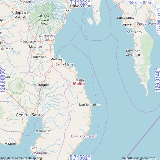
Malita GPS coordinates[2]
6° 24' 54" North, 125° 36' 42.012" East
| Map corner | latitude | longitude |
|---|---|---|
| Upper-left | 7.11323°, | 124.90855° |
| Center: | 6.415°, | 125.61167° |
| Lower-right: | 5.71582°, | 126.3148° |
| Map W x H: | 155.4×155.4 km | = 96.6×96.6mi |
| max Lat: | 20.78733° ⇑96.3% North |
| Malita: | 6.415° |
| min Lat: | ⇓3.7% South 4.65442° |
| min Long | Malita | max Long |
| 117.04868° | 125.61167° | 126.58417° |
| W 94.6%⇐ | ⇒5.4% E |
Elevation
Elevation of Malita is 8 m = 26 ft, and this is 79.9 m = 262 ft below average elevation for this country.
| Max E: |
2262 m = 7421 ft | 85.4% |
| Avg. | 87.9 m = 288 ft | |
| Malita | 8 m = 26 ft | |
Min E: |
-2 m = -7 ft | 14.6% |
See also: Malita elevation on elevation.city.
Geographical zone
Malita is located in North Torrid zone (between Equator and Tropic of Cancer). Distance of Equator is 713.3 km =443.2 mi to South.| Distance of | km | miles | from Malita |
|---|---|---|---|
| North Pole | 9293.8 | 5774.9 | to North |
| Arctic Circle | 6687.9 | 4155.7 | to North |
| Tropic Cancer | 1892.6 | 1176 | to North |
| Equator | 713.3 | 443.2 | to South |


Nearby cities:
15 places around Malita: (largest is in red/bold)
• Basiawan
19.1 km =11.9 mi,  313°
313°
• Bolila
6.6 km =4.1 mi,  222°
222°
• Buhangin
11 km =6.8 mi,  320°
320°
• Bulacan
27 km =16.8 mi, 308°
• Kinangan
13 km =8.1 mi,  193°
193°
• Lacaron
5.2 km =3.2 mi, 316°
• Lais
9.9 km =6.2 mi,  157°
157°
• Lapuan
31.7 km =19.7 mi, 161°
• Malalag
30.9 km =19.2 mi, 310°
• Pangian
9.1 km =5.7 mi, 305°
• Pung-Pang
18.8 km =11.7 mi,  299°
299°
• Santa Maria
21.9 km =13.6 mi, 314°
• Talagutong
17.9 km =11.1 mi, 159°
• Tanlad
27.8 km =17.3 mi, 318°
• Tubalan
10.2 km =6.3 mi,  330°
330°
Sources, notices
• [Note1] Compared only with cities in Philippines existing in our database
• [Src1] Map data: © OpenStreetMap contributors (CC-BY-SA)
• [Src2] Other city data from geonames.org with taken over terms of usage.
• [Src3] Geographical zone / Annual Mean Temperature by Robert A. Rohde @ Wikipedia
