Tubalan geodata
Tubalan (Davao) is a populated place; located in Philippines in Asia/Manila (GMT+8) time zone. With population of 4,164 people, there are 1636 cities with bigger population in this country. Compared to other cities in Philippines, 95.7% of cities are located further ↑North; 94.2% of cities are located further ←West and 60.8% of cities have higher elevation than Tubalan. Note1


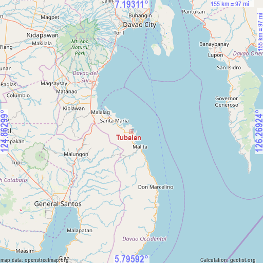
Tubalan GPS coordinates[2]
6° 29' 42" North, 125° 33' 57.996" East
| Map corner | latitude | longitude |
|---|---|---|
| Upper-left | 7.19311°, | 124.86299° |
| Center: | 6.495°, | 125.56611° |
| Lower-right: | 5.79592°, | 126.26924° |
| Map W x H: | 155.4×155.4 km | = 96.6×96.6mi |
| max Lat: | 20.78733° ⇑95.7% North |
| Tubalan: | 6.495° |
| min Lat: | ⇓4.3% South 4.65442° |
| min Long | Tubalan | max Long |
| 117.04868° | 125.56611° | 126.58417° |
| W 94.2%⇐ | ⇒5.8% E |
Elevation
Elevation of Tubalan is 16 m = 52 ft, and this is 71.9 m = 236 ft below average elevation for this country.
| Max E: |
2262 m = 7421 ft | 60.8% |
| Avg. | 87.9 m = 288 ft | |
| Tubalan | 16 m = 52 ft | |
Min E: |
-2 m = -7 ft | 39.2% |
See also: Philippines elevation on elevation.city.
Geographical zone
Tubalan is located in North Torrid zone (between Equator and Tropic of Cancer). Distance of Equator is 722.2 km =448.8 mi to South.| Distance of | km | miles | from Tubalan |
|---|---|---|---|
| North Pole | 9284.9 | 5769.4 | to North |
| Arctic Circle | 6679 | 4150.1 | to North |
| Tropic Cancer | 1883.7 | 1170.5 | to North |
| Equator | 722.2 | 448.8 | to South |


Nearby cities:
15 places around Tubalan: (largest is in red/bold)
• Basiawan
9.8 km =6.1 mi,  296°
296°
• Bolila
13.7 km =8.5 mi,  177°
177°
• Buhangin
2.1 km =1.3 mi,  258°
258°
• Bulacan
17.9 km =11.1 mi, 296°
• Kinangan
21.6 km =13.4 mi,  174°
174°
• Lacaron
5.3 km =3.3 mi,  164°
164°
• Lais
20.1 km =12.5 mi,  153°
153°
• Malalag
21.6 km =13.4 mi, 301°
• Malita
10.2 km =6.3 mi, 150°
• New Baclayon
23.9 km =14.9 mi,  294°
294°
• Pangian
4.3 km =2.7 mi,  212°
212°
• Pung-Pang
11.4 km =7.1 mi,  271°
271°
• Santa Maria
12.4 km =7.7 mi, 301°
• Sulop
27.1 km =16.8 mi, 295°
• Tanlad
17.9 km =11.1 mi,  311°
311°
Sources, notices
• [Note1] Compared only with cities in Philippines existing in our database
• [Src1] Map data: © OpenStreetMap contributors (CC-BY-SA)
• [Src2] Other city data from geonames.org with taken over terms of usage.
• [Src3] Geographical zone / Annual Mean Temperature by Robert A. Rohde @ Wikipedia
