Batan geodata
Batan (Western Visayas) is a seat of a third-order administrative division; located in Philippines in Asia/Manila (GMT+8) time zone. With population of 4,495 people, there are 1494 cities with bigger population in this country. Compared to other cities in Philippines, 50.3% of cities are located further ↑North; 55% of cities are located further →East and 80.7% of cities have higher elevation than Batan. Note1


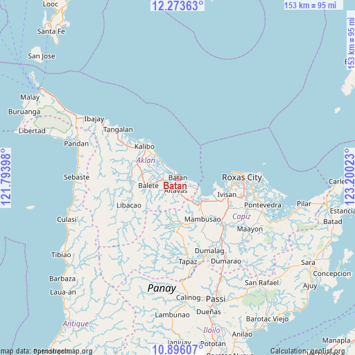
Batan GPS coordinates[2]
11° 35' 8.52" North, 122° 29' 49.56" East
| Map corner | latitude | longitude |
|---|---|---|
| Upper-left | 12.27363°, | 121.79398° |
| Center: | 11.5857°, | 122.4971° |
| Lower-right: | 10.89607°, | 123.20023° |
| Map W x H: | 153.2×153.2 km | = 95.2×95.2mi |
| max Lat: | 20.78733° ⇑50.3% North |
| Batan: | 11.5857° |
| min Lat: | ⇓49.7% South 4.65442° |
| min Long | Batan | max Long |
| 117.04868° | 122.4971° | 126.58417° |
| W 45%⇐ | ⇒55% E |
Elevation
Elevation of Batan is 9 m = 30 ft, and this is 78.9 m = 259 ft below average elevation for this country.
| Max E: |
2262 m = 7421 ft | 80.7% |
| Avg. | 87.9 m = 288 ft | |
| Batan | 9 m = 30 ft | |
Min E: |
-2 m = -7 ft | 19.3% |
See also: Philippines elevation on elevation.city.
Geographical zone
Batan is located in North Torrid zone (between Equator and Tropic of Cancer). Distance of Equator is 1288.2 km =800.5 mi to South.| Distance of | km | miles | from Batan |
|---|---|---|---|
| North Pole | 8718.9 | 5417.7 | to North |
| Arctic Circle | 6113 | 3798.4 | to North |
| Tropic Cancer | 1317.7 | 818.8 | to North |
| Equator | 1288.2 | 800.5 | to South |


Nearby cities:
15 places around Batan: (largest is in red/bold)
• Altavas
5.4 km =3.4 mi,  191°
191°
• Ambulong
0.7 km =0.4 mi,  166°
166°
• Aranas Sur
11.9 km =7.4 mi,  258°
258°
• Bilao
12.8 km =8 mi,  147°
147°
• Calizo
12.1 km =7.5 mi,  268°
268°
• Cawayan
5.5 km =3.4 mi,  320°
320°
• Cortez
12.5 km =7.8 mi,  240°
240°
• Damayan
11.9 km =7.4 mi, 149°
• Lalab
7.6 km =4.7 mi, 260°
• Lonoy
10.2 km =6.3 mi,  143°
143°
• Lupo
8.9 km =5.5 mi, 192°
• Manup
6 km =3.7 mi,  179°
179°
• New Washington
10.1 km =6.3 mi, 315°
• Ochanado
3.5 km =2.2 mi,  334°
334°
• Odiong
6.5 km =4 mi,  210°
210°
Sources, notices
• [Note1] Compared only with cities in Philippines existing in our database
• [Src1] Map data: © OpenStreetMap contributors (CC-BY-SA)
• [Src2] Other city data from geonames.org with taken over terms of usage.
• [Src3] Geographical zone / Annual Mean Temperature by Robert A. Rohde @ Wikipedia
