Barucboc Norte geodata
Barucboc Norte (Cagayan Valley) is a populated place; located in Philippines in Asia/Manila (GMT+8) time zone. With population of 3,020 people, there are 2500 cities with bigger population in this country. Compared to other cities in Philippines, 94.9% of cities are located further ↓South; 65.4% of cities are located further →East and 78.9% of cities have lower elevation than Barucboc Norte. Note1


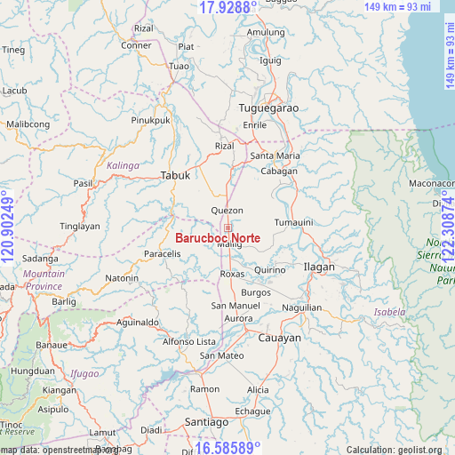
Barucboc Norte GPS coordinates[2]
17° 15' 30.852" North, 121° 36' 20.196" East
| Map corner | latitude | longitude |
|---|---|---|
| Upper-left | 17.9288°, | 120.90249° |
| Center: | 17.25857°, | 121.60561° |
| Lower-right: | 16.58589°, | 122.30874° |
| Map W x H: | 149.3×149.3 km | = 92.8×92.8mi |
| max Lat: | 20.78733° ⇑5.1% North |
| Barucboc Norte: | 17.25857° |
| min Lat: | ⇓94.9% South 4.65442° |
| min Long | Barucboc Norte | max Long |
| 117.04868° | 121.60561° | 126.58417° |
| W 34.6%⇐ | ⇒65.4% E |
Elevation
Elevation of Barucboc Norte is 85 m = 279 ft, and this is 2.9 m = 10 ft below average elevation for this country.
| Max E: |
2262 m = 7421 ft | 21.1% |
| Avg. | 87.9 m = 288 ft | |
| Barucboc Norte | 85 m = 279 ft | |
Min E: |
-2 m = -7 ft | 78.9% |
See also: Philippines elevation on elevation.city.
Geographical zone
Barucboc Norte is located in North Torrid zone (between Equator and Tropic of Cancer). Distance of this Northern Tropic circle is 686.9 km =426.8 mi to North.| Distance of | km | miles | from Barucboc Norte |
|---|---|---|---|
| North Pole | 8088.1 | 5025.7 | to North |
| Arctic Circle | 5482.2 | 3406.5 | to North |
| Tropic Cancer | 686.9 | 426.8 | to North |
| Equator | 1919 | 1192.4 | to South |


Nearby cities:
15 places around Barucboc Norte: (largest is in red/bold)
• Abut
10.6 km =6.6 mi,  357°
357°
• Agbannawag
14.5 km =9 mi,  334°
334°
• Bulu
19 km =11.8 mi,  64°
64°
• Calinaoan Malasin
17.7 km =11 mi,  54°
54°
• Magsaysay
19.1 km =11.9 mi,  73°
73°
• Mallig
5.1 km =3.2 mi,  173°
173°
• Muñoz East
11.3 km =7 mi,  175°
175°
• Paracelis
14.8 km =9.2 mi,  273°
273°
• Quezon
6.1 km =3.8 mi,  0°
0°
• Quirino
17.2 km =10.7 mi,  144°
144°
• Roxas
15.6 km =9.7 mi, 174°
• San Jose
12.1 km =7.5 mi, 182°
• Santo Domingo
19 km =11.8 mi,  125°
125°
• Siempre Viva
4.4 km =2.7 mi, 138°
• Simimbaan
15.8 km =9.8 mi,  189°
189°
Sources, notices
• [Note1] Compared only with cities in Philippines existing in our database
• [Src1] Map data: © OpenStreetMap contributors (CC-BY-SA)
• [Src2] Other city data from geonames.org with taken over terms of usage.
• [Src3] Geographical zone / Annual Mean Temperature by Robert A. Rohde @ Wikipedia
