Agbannawag geodata
Agbannawag (Cordillera) is a populated place; located in Philippines in Asia/Manila (GMT+8) time zone. With population of 3,186 people, there are 2324 cities with bigger population in this country. Compared to other cities in Philippines, 95.5% of cities are located further ↓South; 65.9% of cities are located further →East and 88.8% of cities have lower elevation than Agbannawag. Note1


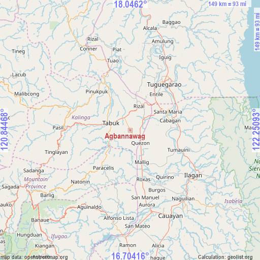
Agbannawag GPS coordinates[2]
17° 22' 35.076" North, 121° 32' 52.08" East
| Map corner | latitude | longitude |
|---|---|---|
| Upper-left | 18.0462°, | 120.84468° |
| Center: | 17.37641°, | 121.5478° |
| Lower-right: | 16.70416°, | 122.25093° |
| Map W x H: | 149.2×149.2 km | = 92.7×92.7mi |
| max Lat: | 20.78733° ⇑4.5% North |
| Agbannawag: | 17.37641° |
| min Lat: | ⇓95.5% South 4.65442° |
| min Long | Agbannawag | max Long |
| 117.04868° | 121.5478° | 126.58417° |
| W 34.1%⇐ | ⇒65.9% E |
Elevation
Elevation of Agbannawag is 199 m = 653 ft, and this is 111.1 m = 365 ft above average elevation for this country.
| Max E: |
2262 m = 7421 ft | 11.2% |
| Agbannawag | 199 m 653 ft | |
| Avg. | 87.9 m = 288 ft | |
Min E: |
-2 m = -7 ft | 88.8% |
See also: Philippines elevation on elevation.city.
Geographical zone
Agbannawag is located in North Torrid zone (between Equator and Tropic of Cancer). Distance of this Northern Tropic circle is 673.8 km =418.7 mi to North.| Distance of | km | miles | from Agbannawag |
|---|---|---|---|
| North Pole | 8075 | 5017.6 | to North |
| Arctic Circle | 5469.1 | 3398.3 | to North |
| Tropic Cancer | 673.8 | 418.7 | to North |
| Equator | 1932.1 | 1200.6 | to South |


Nearby cities:
15 places around Agbannawag: (largest is in red/bold)
• Abut
6.2 km =3.9 mi,  113°
113°
• Barucboc Norte
14.5 km =9 mi,  154°
154°
• Bulu
23.7 km =14.7 mi,  101°
101°
• Calinaoan Malasin
20.7 km =12.9 mi, 97°
• Laya
13.7 km =8.5 mi,  321°
321°
• Liwan
18.2 km =11.3 mi,  29°
29°
• Mallig
19.4 km =12.1 mi,  159°
159°
• Mozzozzin Sur
22.9 km =14.2 mi,  66°
66°
• Paracelis
14.9 km =9.3 mi,  215°
215°
• Quezon
9.4 km =5.8 mi,  138°
138°
• San Bernardo
21.8 km =13.5 mi,  81°
81°
• San Juan
21.4 km =13.3 mi, 81°
• Santo Tomas
23.1 km =14.4 mi, 83°
• Siempre Viva
18.7 km =11.6 mi, 151°
• Tabuk
13.7 km =8.5 mi, 321°
Sources, notices
• [Note1] Compared only with cities in Philippines existing in our database
• [Src1] Map data: © OpenStreetMap contributors (CC-BY-SA)
• [Src2] Other city data from geonames.org with taken over terms of usage.
• [Src3] Geographical zone / Annual Mean Temperature by Robert A. Rohde @ Wikipedia
