Muñoz East geodata
Muñoz East (Cagayan Valley) is a populated place; located in Philippines in Asia/Manila (GMT+8) time zone. With population of 5,198 people, there are 1230 cities with bigger population in this country. Compared to other cities in Philippines, 94.5% of cities are located further ↓South; 65.2% of cities are located further →East and 74.1% of cities have lower elevation than Muñoz East. Note1


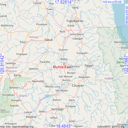
Muñoz East GPS coordinates[2]
17° 9' 27.144" North, 121° 36' 48.744" East
| Map corner | latitude | longitude |
|---|---|---|
| Upper-left | 17.82814°, | 120.91042° |
| Center: | 17.15754°, | 121.61354° |
| Lower-right: | 16.4845°, | 122.31667° |
| Map W x H: | 149.4×149.4 km | = 92.8×92.8mi |
| max Lat: | 20.78733° ⇑5.5% North |
| Muñoz East: | 17.15754° |
| min Lat: | ⇓94.5% South 4.65442° |
| min Long | Muñoz East | max Long |
| 117.04868° | 121.61354° | 126.58417° |
| W 34.8%⇐ | ⇒65.2% E |
Elevation
Elevation of Muñoz East is 65 m = 213 ft, and this is 22.9 m = 75 ft below average elevation for this country.
| Max E: |
2262 m = 7421 ft | 25.9% |
| Avg. | 87.9 m = 288 ft | |
| Muñoz East | 65 m = 213 ft | |
Min E: |
-2 m = -7 ft | 74.1% |
See also: Philippines elevation on elevation.city.
Geographical zone
Muñoz East is located in North Torrid zone (between Equator and Tropic of Cancer). Distance of this Northern Tropic circle is 698.2 km =433.8 mi to North.| Distance of | km | miles | from Muñoz East |
|---|---|---|---|
| North Pole | 8099.3 | 5032.7 | to North |
| Arctic Circle | 5493.4 | 3413.4 | to North |
| Tropic Cancer | 698.2 | 433.8 | to North |
| Equator | 1907.7 | 1185.4 | to South |


Nearby cities:
15 places around Muñoz East: (largest is in red/bold)
• Barucboc Norte
11.3 km =7 mi,  355°
355°
• Burgos
12.1 km =7.5 mi,  128°
128°
• Cullalabo del Sur
11.4 km =7.1 mi,  122°
122°
• Eden
13.4 km =8.3 mi,  187°
187°
• Mabini
14.4 km =8.9 mi, 116°
• Mallig
6.2 km =3.9 mi, 357°
• Quirino
9.6 km =6 mi,  106°
106°
• Roxas
4.3 km =2.7 mi,  170°
170°
• San Jose
1.7 km =1.1 mi,  239°
239°
• San Manuel
15.1 km =9.4 mi, 170°
• San Mateo
14.2 km =8.8 mi,  99°
99°
• Sandiat Centro
9.7 km =6 mi,  164°
164°
• Santo Domingo
14.7 km =9.1 mi,  88°
88°
• Siempre Viva
8.2 km =5.1 mi,  14°
14°
• Simimbaan
5.5 km =3.4 mi,  218°
218°
Sources, notices
• [Note1] Compared only with cities in Philippines existing in our database
• [Src1] Map data: © OpenStreetMap contributors (CC-BY-SA)
• [Src2] Other city data from geonames.org with taken over terms of usage.
• [Src3] Geographical zone / Annual Mean Temperature by Robert A. Rohde @ Wikipedia
