Banhigan geodata
Banhigan (Central Visayas) is a populated place; located in Philippines in Asia/Manila (GMT+8) time zone. With population of 2,359 people, there are 3540 cities with bigger population in this country. Compared to other cities in Philippines, 69.8% of cities are located further ↑North; 60% of cities are located further ←West and 53.1% of cities have higher elevation than Banhigan. Note1


Banhigan GPS coordinates[2]
9° 51' 32.508" North, 123° 23' 21.336" East
| Map corner | latitude | longitude |
|---|---|---|
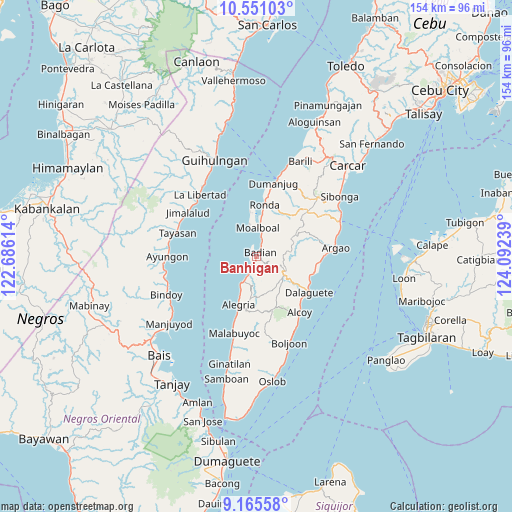
| Upper-left | 10.55103°, | 122.68614° |
| Center: | 9.85903°, | 123.38926° |
| Lower-right: | 9.16558°, | 124.09239° |
| Map W x H: | 154×154.1 km | = 95.7×95.8mi |
| max Lat: | 20.78733° ⇑69.8% North |
| Banhigan: | 9.85903° |
| min Lat: | ⇓30.2% South 4.65442° |
| min Long | Banhigan | max Long |
| 117.04868° | 123.38926° | 126.58417° |
| W 60%⇐ | ⇒40% E |
Elevation
Elevation of Banhigan is 21 m = 69 ft, and this is 66.9 m = 219 ft below average elevation for this country.
| Max E: |
2262 m = 7421 ft | 53.1% |
| Avg. | 87.9 m = 288 ft | |
| Banhigan | 21 m = 69 ft | |
Min E: |
-2 m = -7 ft | 46.9% |
See also: Philippines elevation on elevation.city.
Geographical zone
Banhigan is located in North Torrid zone (between Equator and Tropic of Cancer). Distance of Equator is 1096.2 km =681.1 mi to South.| Distance of | km | miles | from Banhigan |
|---|---|---|---|
| North Pole | 8910.8 | 5536.9 | to North |
| Arctic Circle | 6305 | 3917.7 | to North |
| Tropic Cancer | 1509.7 | 938.1 | to North |
| Equator | 1096.2 | 681.1 | to South |


Nearby cities:
15 places around Banhigan: (largest is in red/bold)
• Alcantara
13.1 km =8.1 mi,  8°
8°
• Badian
1 km =0.6 mi,  50°
50°
• Basdiot
9.9 km =6.2 mi,  351°
351°
• Bugas
4.7 km =2.9 mi,  21°
21°
• Cansuje
13.7 km =8.5 mi,  58°
58°
• Guadalupe
15.1 km =9.4 mi,  174°
174°
• Madridejos
8.9 km =5.5 mi,  212°
212°
• Malbug
15 km =9.3 mi,  200°
200°
• Malhiao
3.4 km =2.1 mi,  33°
33°
• Mantalongon
9.6 km =6 mi,  124°
124°
• Moalboal
9.4 km =5.8 mi, 6°
• Saavedra
14.2 km =8.8 mi, 352°
• Santa Filomena
12.9 km =8 mi, 202°
• Tabon
9.5 km =5.9 mi,  129°
129°
• Valencia
10 km =6.2 mi,  193°
193°
Sources, notices
• [Note1] Compared only with cities in Philippines existing in our database
• [Src1] Map data: © OpenStreetMap contributors (CC-BY-SA)
• [Src2] Other city data from geonames.org with taken over terms of usage.
• [Src3] Geographical zone / Annual Mean Temperature by Robert A. Rohde @ Wikipedia
