Madridejos geodata
Madridejos (Central Visayas) is a seat of a second-order administrative division; located in Philippines in Asia/Manila (GMT+8) time zone. With population of 6,387 people, there are 978 cities with bigger population in this country. Compared to other cities in Philippines, 70.5% of cities are located further ↑North; 59.3% of cities are located further ←West and 99.6% of cities have higher elevation than Madridejos. Note1


Madridejos GPS coordinates[2]
9° 47' 28.176" North, 123° 20' 46.32" East
| Map corner | latitude | longitude |
|---|---|---|
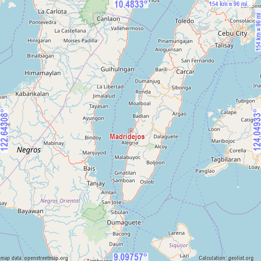
| Upper-left | 10.4833°, | 122.64308° |
| Center: | 9.79116°, | 123.3462° |
| Lower-right: | 9.09757°, | 124.04933° |
| Map W x H: | 154.1×154.1 km | = 95.8×95.8mi |
| max Lat: | 20.78733° ⇑70.5% North |
| Madridejos: | 9.79116° |
| min Lat: | ⇓29.5% South 4.65442° |
| min Long | Madridejos | max Long |
| 117.04868° | 123.3462° | 126.58417° |
| W 59.3%⇐ | ⇒40.7% E |
Elevation
Elevation of Madridejos is 1 m = 3 ft, and this is 86.9 m = 285 ft below average elevation for this country.
| Max E: |
2262 m = 7421 ft | 99.6% |
| Avg. | 87.9 m = 288 ft | |
| Madridejos | 1 m = 3 ft | |
Min E: |
-2 m = -7 ft | 0.4% |
See also: Philippines elevation on elevation.city.
Geographical zone
Madridejos is located in North Torrid zone (between Equator and Tropic of Cancer). Distance of Equator is 1088.7 km =676.5 mi to South.| Distance of | km | miles | from Madridejos |
|---|---|---|---|
| North Pole | 8918.4 | 5541.6 | to North |
| Arctic Circle | 6312.5 | 3922.4 | to North |
| Tropic Cancer | 1517.2 | 942.7 | to North |
| Equator | 1088.7 | 676.5 | to South |


Nearby cities:
15 places around Madridejos: (largest is in red/bold)
• Alegria
7 km =4.3 mi,  185°
185°
• Badian
9.9 km =6.2 mi,  33°
33°
• Banhigan
8.9 km =5.5 mi, 32°
• Bugas
13.5 km =8.4 mi, 28°
• Guadalupe
9.7 km =6 mi,  140°
140°
• Lepanto
13.4 km =8.3 mi,  152°
152°
• Malabuyoc
15.6 km =9.7 mi, 188°
• Malbug
6.5 km =4 mi, 185°
• Malhiao
12.3 km =7.6 mi, 32°
• Mantalongon
12.8 km =8 mi,  80°
80°
• Montaneza
12 km =7.5 mi, 189°
• Nugas
14.8 km =9.2 mi, 135°
• Santa Filomena
4.4 km =2.7 mi,  182°
182°
• Tabon
12.2 km =7.6 mi, 83°
• Valencia
3.2 km =2 mi,  133°
133°
Sources, notices
• [Note1] Compared only with cities in Philippines existing in our database
• [Src1] Map data: © OpenStreetMap contributors (CC-BY-SA)
• [Src2] Other city data from geonames.org with taken over terms of usage.
• [Src3] Geographical zone / Annual Mean Temperature by Robert A. Rohde @ Wikipedia
