Santa Filomena geodata
Santa Filomena (Central Visayas) is a populated place; located in Philippines in Asia/Manila (GMT+8) time zone. With population of 2,932 people, there are 2606 cities with bigger population in this country. Compared to other cities in Philippines, 71% of cities are located further ↑North; 59.3% of cities are located further ←West and 72.2% of cities have lower elevation than Santa Filomena. Note1


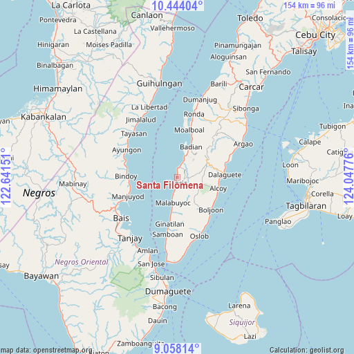
Santa Filomena GPS coordinates[2]
9° 45' 6.516" North, 123° 20' 40.668" East
| Map corner | latitude | longitude |
|---|---|---|
| Upper-left | 10.44404°, | 122.64151° |
| Center: | 9.75181°, | 123.34463° |
| Lower-right: | 9.05814°, | 124.04776° |
| Map W x H: | 154.1×154.1 km | = 95.8×95.8mi |
| max Lat: | 20.78733° ⇑71% North |
| Santa Filomena: | 9.75181° |
| min Lat: | ⇓29% South 4.65442° |
| min Long | Santa Filomena | max Long |
| 117.04868° | 123.34463° | 126.58417° |
| W 59.3%⇐ | ⇒40.7% E |
Elevation
Elevation of Santa Filomena is 58 m = 190 ft, and this is 29.9 m = 98 ft below average elevation for this country.
| Max E: |
2262 m = 7421 ft | 27.8% |
| Avg. | 87.9 m = 288 ft | |
| Santa Filomena | 58 m = 190 ft | |
Min E: |
-2 m = -7 ft | 72.2% |
See also: Philippines elevation on elevation.city.
Geographical zone
Santa Filomena is located in North Torrid zone (between Equator and Tropic of Cancer). Distance of Equator is 1084.3 km =673.8 mi to South.| Distance of | km | miles | from Santa Filomena |
|---|---|---|---|
| North Pole | 8922.8 | 5544.4 | to North |
| Arctic Circle | 6316.9 | 3925.1 | to North |
| Tropic Cancer | 1521.6 | 945.5 | to North |
| Equator | 1084.3 | 673.8 | to South |


Nearby cities:
15 places around Santa Filomena: (largest is in red/bold)
• Alegria
2.6 km =1.6 mi,  191°
191°
• Badian
13.8 km =8.6 mi,  24°
24°
• Banhigan
12.9 km =8 mi, 22°
• Becerril
14.7 km =9.1 mi,  138°
138°
• Guadalupe
7 km =4.3 mi,  116°
116°
• Lepanto
9.8 km =6.1 mi, 139°
• Madridejos
4.4 km =2.7 mi,  2°
2°
• Malabuyoc
11.2 km =7 mi, 190°
• Malbug
2.2 km =1.4 mi, 192°
• Mantalongon
14.4 km =8.9 mi,  62°
62°
• Montaneza
7.7 km =4.8 mi, 192°
• Nugas
12.3 km =7.6 mi, 119°
• Tabon
13.6 km =8.5 mi, 64°
• Talangnan
13.1 km =8.1 mi,  184°
184°
• Valencia
3.3 km =2.1 mi,  48°
48°
Sources, notices
• [Note1] Compared only with cities in Philippines existing in our database
• [Src1] Map data: © OpenStreetMap contributors (CC-BY-SA)
• [Src2] Other city data from geonames.org with taken over terms of usage.
• [Src3] Geographical zone / Annual Mean Temperature by Robert A. Rohde @ Wikipedia
