Banganan geodata
Banganan (Cagayan Valley) is a populated place; located in Philippines in Asia/Manila (GMT+8) time zone. With population of 2,594 people, there are 3117 cities with bigger population in this country. Compared to other cities in Philippines, 89.9% of cities are located further ↓South; 75% of cities are located further →East and 93.8% of cities have lower elevation than Banganan. Note1
Administrative division(s):
- Level 1: Cagayan Valley
- Level 2: Province of Nueva Vizcaya
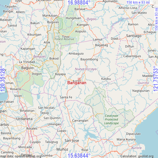
- Level 3: Aritao


Banganan GPS coordinates[2]
16° 18' 51.84" North, 121° 3' 15.84" East
| Map corner | latitude | longitude |
|---|---|---|
| Upper-left | 16.98804°, | 120.35128° |
| Center: | 16.3144°, | 121.0544° |
| Lower-right: | 15.63844°, | 121.75753° |
| Map W x H: | 150.1×150.1 km | = 93.3×93.3mi |
| max Lat: | 20.78733° ⇑10.1% North |
| Banganan: | 16.3144° |
| min Lat: | ⇓89.9% South 4.65442° |
| min Long | Banganan | max Long |
| 117.04868° | 121.0544° | 126.58417° |
| W 25%⇐ | ⇒75% E |
Elevation
Elevation of Banganan is 360 m = 1181 ft, and this is 272.1 m = 893 ft above average elevation for this country.
| Max E: |
2262 m = 7421 ft | 6.2% |
| Banganan | 360 m 1181 ft | |
| Avg. | 87.9 m = 288 ft | |
Min E: |
-2 m = -7 ft | 93.8% |
See also: Philippines elevation on elevation.city.
Geographical zone
Banganan is located in North Torrid zone (between Equator and Tropic of Cancer). Distance of this Northern Tropic circle is 791.9 km =492.1 mi to North.| Distance of | km | miles | from Banganan |
|---|---|---|---|
| North Pole | 8193.1 | 5091 | to North |
| Arctic Circle | 5587.2 | 3471.7 | to North |
| Tropic Cancer | 791.9 | 492.1 | to North |
| Equator | 1814 | 1127.2 | to South |


Nearby cities:
15 places around Banganan: (largest is in red/bold)
• Almaguer North
5.7 km =3.5 mi,  46°
46°
• Aritao
2.8 km =1.7 mi,  229°
229°
• Bambang
9.8 km =6.1 mi,  34°
34°
• Bayombong
21.1 km =13.1 mi, 28°
• Belance
25.5 km =15.8 mi,  124°
124°
• Bone South
10 km =6.2 mi,  218°
218°
• Busilak
19.6 km =12.2 mi,  22°
22°
• Ineangan
4.1 km =2.5 mi,  84°
84°
• Kayapa
18.6 km =11.6 mi,  285°
285°
• Mabasa
7.7 km =4.8 mi, 84°
• Malasin
5.6 km =3.5 mi,  101°
101°
• Salinas
7.2 km =4.5 mi,  328°
328°
• San Antonio
7.1 km =4.4 mi,  55°
55°
• San Fernando
11.8 km =7.3 mi, 45°
• Santa Fe
21.2 km =13.2 mi, 215°
Sources, notices
• [Note1] Compared only with cities in Philippines existing in our database
• [Src1] Map data: © OpenStreetMap contributors (CC-BY-SA)
• [Src2] Other city data from geonames.org with taken over terms of usage.
• [Src3] Geographical zone / Annual Mean Temperature by Robert A. Rohde @ Wikipedia
