Santa Fe geodata
Santa Fe (Cagayan Valley) is a seat of a third-order administrative division; located in Philippines in Asia/Manila (GMT+8) time zone. In our database, there are 4166 cities with bigger population. Compared to other cities in Philippines, 89.1% of cities are located further ↓South; 78.2% of cities are located further →East and 96.6% of cities have lower elevation than Santa Fe. Note1
Administrative division(s):
- Level 1: Cagayan Valley
- Level 2: Province of Nueva Vizcaya
- Level 3: Santa Fe


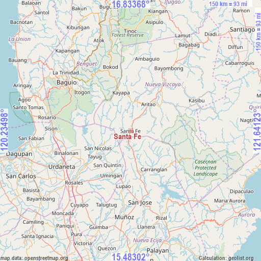
Santa Fe GPS coordinates[2]
16° 9' 34.2" North, 120° 56' 17.16" East
| Map corner | latitude | longitude |
|---|---|---|
| Upper-left | 16.83368°, | 120.23498° |
| Center: | 16.1595°, | 120.9381° |
| Lower-right: | 15.48302°, | 121.64123° |
| Map W x H: | 150.2×150.2 km | = 93.3×93.3mi |
| max Lat: | 20.78733° ⇑10.9% North |
| Santa Fe: | 16.1595° |
| min Lat: | ⇓89.1% South 4.65442° |
| min Long | Santa Fe | max Long |
| 117.04868° | 120.9381° | 126.58417° |
| W 21.8%⇐ | ⇒78.2% E |
Elevation
Elevation of Santa Fe is 567 m = 1860 ft, and this is 479.1 m = 1572 ft above average elevation for this country.
| Max E: |
2262 m = 7421 ft | 3.4% |
| Santa Fe | 567 m 1860 ft | |
| Avg. | 87.9 m = 288 ft | |
Min E: |
-2 m = -7 ft | 96.6% |
See also: Philippines elevation on elevation.city.
Geographical zone
Santa Fe is located in North Torrid zone (between Equator and Tropic of Cancer). Distance of this Northern Tropic circle is 809.2 km =502.8 mi to North.| Distance of | km | miles | from Santa Fe |
|---|---|---|---|
| North Pole | 8210.3 | 5101.6 | to North |
| Arctic Circle | 5604.4 | 3482.4 | to North |
| Tropic Cancer | 809.2 | 502.8 | to North |
| Equator | 1796.8 | 1116.5 | to South |


Nearby cities:
15 places around Santa Fe: (largest is in red/bold)
• Alac
23.7 km =14.7 mi,  216°
216°
• Aritao
18.5 km =11.5 mi,  33°
33°
• Banganan
21.2 km =13.2 mi,  35°
35°
• Bone South
11.3 km =7 mi, 33°
• Burgos
15.4 km =9.6 mi,  129°
129°
• Cabalitian
17.5 km =10.9 mi,  243°
243°
• Carriedo
24.2 km =15 mi,  233°
233°
• Digdig
23.8 km =14.8 mi,  169°
169°
• Ineangan
24.2 km =15 mi, 43°
• Kayapa
22.9 km =14.2 mi,  346°
346°
• Lagasit
24 km =14.9 mi, 219°
• Malasin
24.1 km =15 mi,  48°
48°
• Natividad
19.6 km =12.2 mi, 229°
• San Nicolas
21.2 km =13.2 mi, 242°
• San Quintin
23.5 km =14.6 mi,  214°
214°
Sources, notices
• [Note1] Compared only with cities in Philippines existing in our database
• [Src1] Map data: © OpenStreetMap contributors (CC-BY-SA)
• [Src2] Other city data from geonames.org with taken over terms of usage.
• [Src3] Geographical zone / Annual Mean Temperature by Robert A. Rohde @ Wikipedia
