Banate geodata
Banate (Western Visayas) is a seat of a third-order administrative division; located in Philippines in Asia/Manila (GMT+8) time zone. In our database, there are 4166 cities with bigger population. Compared to other cities in Philippines, 56.9% of cities are located further ↑North; 50.1% of cities are located further ←West and 89.7% of cities have higher elevation than Banate. Note1


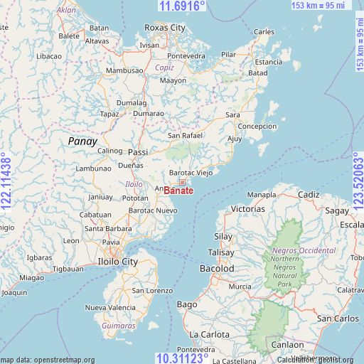
Banate GPS coordinates[2]
11° 0' 7.992" North, 122° 49' 3" East
| Map corner | latitude | longitude |
|---|---|---|
| Upper-left | 11.6916°, | 122.11438° |
| Center: | 11.00222°, | 122.8175° |
| Lower-right: | 10.31123°, | 123.52063° |
| Map W x H: | 153.5×153.5 km | = 95.4×95.4mi |
| max Lat: | 20.78733° ⇑56.9% North |
| Banate: | 11.00222° |
| min Lat: | ⇓43.1% South 4.65442° |
| min Long | Banate | max Long |
| 117.04868° | 122.8175° | 126.58417° |
| W 50.1%⇐ | ⇒49.9% E |
Elevation
Elevation of Banate is 7 m = 23 ft, and this is 80.9 m = 265 ft below average elevation for this country.
| Max E: |
2262 m = 7421 ft | 89.7% |
| Avg. | 87.9 m = 288 ft | |
| Banate | 7 m = 23 ft | |
Min E: |
-2 m = -7 ft | 10.3% |
See also: Philippines elevation on elevation.city.
Geographical zone
Banate is located in North Torrid zone (between Equator and Tropic of Cancer). Distance of Equator is 1223.3 km =760.1 mi to South.| Distance of | km | miles | from Banate |
|---|---|---|---|
| North Pole | 8783.7 | 5457.9 | to North |
| Arctic Circle | 6177.8 | 3838.7 | to North |
| Tropic Cancer | 1382.6 | 859.1 | to North |
| Equator | 1223.3 | 760.1 | to South |


Nearby cities:
15 places around Banate: (largest is in red/bold)
• Anilao
7.6 km =4.7 mi,  249°
249°
• Barotac Viejo
5.8 km =3.6 mi,  40°
40°
• Bay-ang
14 km =8.7 mi,  75°
75°
• Bolilao
16.1 km =10 mi,  214°
214°
• Carmelo
1.6 km =1 mi,  356°
356°
• De la Paz
8.1 km =5 mi,  328°
328°
• Dingle
16 km =9.9 mi,  268°
268°
• Ermita
15.8 km =9.8 mi,  224°
224°
• Jalaud
14.3 km =8.9 mi, 212°
• Libertad
6.4 km =4 mi,  305°
305°
• Mapili
14.5 km =9 mi,  324°
324°
• San Salvador
1.9 km =1.2 mi,  88°
88°
• Santiago
12 km =7.5 mi,  58°
58°
• Talokgañgan
3.1 km =1.9 mi, 78°
• Tiwi
12.2 km =7.6 mi,  228°
228°
Sources, notices
• [Note1] Compared only with cities in Philippines existing in our database
• [Src1] Map data: © OpenStreetMap contributors (CC-BY-SA)
• [Src2] Other city data from geonames.org with taken over terms of usage.
• [Src3] Geographical zone / Annual Mean Temperature by Robert A. Rohde @ Wikipedia
