Barotac Viejo geodata
Barotac Viejo (Western Visayas) is a seat of a third-order administrative division; located in Philippines in Asia/Manila (GMT+8) time zone. With population of 8,611 people, there are 719 cities with bigger population in this country. Compared to other cities in Philippines, 56.5% of cities are located further ↑North; 50.7% of cities are located further ←West and 76.6% of cities have higher elevation than Barotac Viejo. Note1
Administrative division(s):
- Level 1: Western Visayas
- Level 2: Province of Iloilo
- Level 3: Barotac Viejo


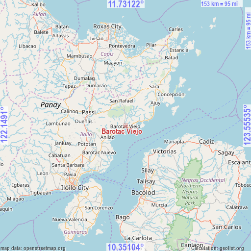
Barotac Viejo GPS coordinates[2]
11° 2' 30.984" North, 122° 51' 7.992" East
| Map corner | latitude | longitude |
|---|---|---|
| Upper-left | 11.73122°, | 122.1491° |
| Center: | 11.04194°, | 122.85222° |
| Lower-right: | 10.35104°, | 123.55535° |
| Map W x H: | 153.5×153.5 km | = 95.4×95.4mi |
| max Lat: | 20.78733° ⇑56.5% North |
| Barotac Viejo: | 11.04194° |
| min Lat: | ⇓43.5% South 4.65442° |
| min Long | Barotac Viejo | max Long |
| 117.04868° | 122.85222° | 126.58417° |
| W 50.7%⇐ | ⇒49.3% E |
Elevation
Elevation of Barotac Viejo is 10 m = 33 ft, and this is 77.9 m = 256 ft below average elevation for this country.
| Max E: |
2262 m = 7421 ft | 76.6% |
| Avg. | 87.9 m = 288 ft | |
| Barotac Viejo | 10 m = 33 ft | |
Min E: |
-2 m = -7 ft | 23.4% |
See also: Philippines elevation on elevation.city.
Geographical zone
Barotac Viejo is located in North Torrid zone (between Equator and Tropic of Cancer). Distance of Equator is 1227.7 km =762.9 mi to South.| Distance of | km | miles | from Barotac Viejo |
|---|---|---|---|
| North Pole | 8779.3 | 5455.2 | to North |
| Arctic Circle | 6173.4 | 3836 | to North |
| Tropic Cancer | 1378.2 | 856.4 | to North |
| Equator | 1227.7 | 762.9 | to South |


Nearby cities:
15 places around Barotac Viejo: (largest is in red/bold)
• Abaca
18.1 km =11.2 mi,  304°
304°
• Anilao
13 km =8.1 mi,  236°
236°
• Banate
5.8 km =3.6 mi,  220°
220°
• Bay-ang
9.8 km =6.1 mi,  94°
94°
• Carmelo
4.8 km =3 mi,  234°
234°
• Culasi
14.7 km =9.1 mi,  73°
73°
• De la Paz
8.4 km =5.2 mi,  287°
287°
• Jaguimitan
17.8 km =11.1 mi,  307°
307°
• Libertad
9.1 km =5.7 mi,  265°
265°
• Mapili
14.4 km =8.9 mi, 300°
• San Rafael
15.4 km =9.6 mi,  349°
349°
• San Salvador
4.7 km =2.9 mi,  203°
203°
• Santiago
6.7 km =4.2 mi, 74°
• Talokgañgan
3.9 km =2.4 mi,  191°
191°
• Tiwi
17.9 km =11.1 mi, 225°
Sources, notices
• [Note1] Compared only with cities in Philippines existing in our database
• [Src1] Map data: © OpenStreetMap contributors (CC-BY-SA)
• [Src2] Other city data from geonames.org with taken over terms of usage.
• [Src3] Geographical zone / Annual Mean Temperature by Robert A. Rohde @ Wikipedia
