Mapili geodata
Mapili (Western Visayas) is a populated place; located in Philippines in Asia/Manila (GMT+8) time zone. With population of 2,104 people, there are 4067 cities with bigger population in this country. Compared to other cities in Philippines, 55.7% of cities are located further ↑North; 50.9% of cities are located further →East and 80.4% of cities have lower elevation than Mapili. Note1
Administrative division(s):
- Level 1: Western Visayas
- Level 2: Province of Iloilo
- Level 3: San Enrique


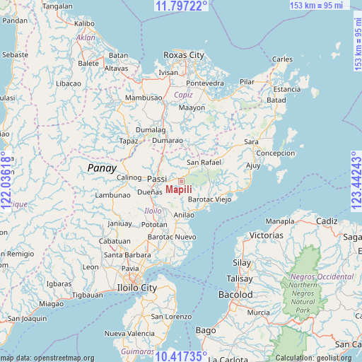
Mapili GPS coordinates[2]
11° 6' 29.16" North, 122° 44' 21.48" East
| Map corner | latitude | longitude |
|---|---|---|
| Upper-left | 11.79722°, | 122.03618° |
| Center: | 11.1081°, | 122.7393° |
| Lower-right: | 10.41735°, | 123.44243° |
| Map W x H: | 153.4×153.4 km | = 95.3×95.3mi |
| max Lat: | 20.78733° ⇑55.7% North |
| Mapili: | 11.1081° |
| min Lat: | ⇓44.3% South 4.65442° |
| min Long | Mapili | max Long |
| 117.04868° | 122.7393° | 126.58417° |
| W 49.1%⇐ | ⇒50.9% E |
Elevation
Elevation of Mapili is 94 m = 308 ft, and this is 6.1 m = 20 ft above average elevation for this country.
| Max E: |
2262 m = 7421 ft | 19.6% |
| Mapili | 94 m 308 ft | |
| Avg. | 87.9 m = 288 ft | |
Min E: |
-2 m = -7 ft | 80.4% |
See also: Philippines elevation on elevation.city.
Geographical zone
Mapili is located in North Torrid zone (between Equator and Tropic of Cancer). Distance of Equator is 1235.1 km =767.5 mi to South.| Distance of | km | miles | from Mapili |
|---|---|---|---|
| North Pole | 8772 | 5450.7 | to North |
| Arctic Circle | 6166.1 | 3831.4 | to North |
| Tropic Cancer | 1370.8 | 851.8 | to North |
| Equator | 1235.1 | 767.5 | to South |


Nearby cities:
15 places around Mapili: (largest is in red/bold)
• Abaca
3.9 km =2.4 mi,  318°
318°
• Aglalana
12 km =7.5 mi,  311°
311°
• Alimono
9.1 km =5.7 mi,  341°
341°
• Banate
14.5 km =9 mi,  144°
144°
• Barotac Viejo
14.4 km =8.9 mi,  120°
120°
• Carmelo
13.2 km =8.2 mi, 140°
• De la Paz
6.5 km =4 mi, 138°
• Dingle
14.2 km =8.8 mi,  211°
211°
• Dueñas
14.3 km =8.9 mi,  251°
251°
• Jaguimitan
3.9 km =2.4 mi,  334°
334°
• Libertad
8.7 km =5.4 mi,  157°
157°
• Passi
10.6 km =6.6 mi,  269°
269°
• Ponong
12.7 km =7.9 mi,  257°
257°
• San Enrique
10 km =6.2 mi, 245°
• San Rafael
12.4 km =7.7 mi,  50°
50°
Sources, notices
• [Note1] Compared only with cities in Philippines existing in our database
• [Src1] Map data: © OpenStreetMap contributors (CC-BY-SA)
• [Src2] Other city data from geonames.org with taken over terms of usage.
• [Src3] Geographical zone / Annual Mean Temperature by Robert A. Rohde @ Wikipedia
