Balucuc geodata
Balucuc (Central Luzon) is a populated place; located in Philippines in Asia/Manila (GMT+8) time zone. With population of 9,214 people, there are 667 cities with bigger population in this country. Compared to other cities in Philippines, 77% of cities are located further ↓South; 81.8% of cities are located further →East and 85.4% of cities have higher elevation than Balucuc. Note1


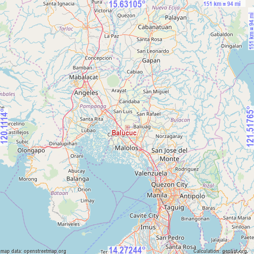
Balucuc GPS coordinates[2]
14° 57' 10.152" North, 120° 48' 52.272" East
| Map corner | latitude | longitude |
|---|---|---|
| Upper-left | 15.63105°, | 120.1114° |
| Center: | 14.95282°, | 120.81452° |
| Lower-right: | 14.27244°, | 121.51765° |
| Map W x H: | 151.1×151.1 km | = 93.9×93.9mi |
| max Lat: | 20.78733° ⇑23% North |
| Balucuc: | 14.95282° |
| min Lat: | ⇓77% South 4.65442° |
| min Long | Balucuc | max Long |
| 117.04868° | 120.81452° | 126.58417° |
| W 18.2%⇐ | ⇒81.8% E |
Elevation
Elevation of Balucuc is 8 m = 26 ft, and this is 79.9 m = 262 ft below average elevation for this country.
| Max E: |
2262 m = 7421 ft | 85.4% |
| Avg. | 87.9 m = 288 ft | |
| Balucuc | 8 m = 26 ft | |
Min E: |
-2 m = -7 ft | 14.6% |
See also: Philippines elevation on elevation.city.
Geographical zone
Balucuc is located in North Torrid zone (between Equator and Tropic of Cancer). Distance of this Northern Tropic circle is 943.3 km =586.1 mi to North.| Distance of | km | miles | from Balucuc |
|---|---|---|---|
| North Pole | 8344.5 | 5185 | to North |
| Arctic Circle | 5738.6 | 3565.8 | to North |
| Tropic Cancer | 943.3 | 586.1 | to North |
| Equator | 1662.6 | 1033.1 | to South |


Nearby cities:
15 places around Balucuc: (largest is in red/bold)
• Apalit
4.8 km =3 mi,  270°
270°
• Balite
7 km =4.3 mi,  204°
204°
• Baliuag
8.9 km =5.5 mi,  88°
88°
• Calumpit
6.6 km =4.1 mi,  232°
232°
• Dampol
5.8 km =3.6 mi,  172°
172°
• Lourdes
8.4 km =5.2 mi,  27°
27°
• Plaridel
8.6 km =5.3 mi,  147°
147°
• Pulilan
6.8 km =4.2 mi, 146°
• San Isidro
7.6 km =4.7 mi,  4°
4°
• San Jose
9.6 km =6 mi,  339°
339°
• San Simon
6.3 km =3.9 mi,  325°
325°
• San Vicente
7.1 km =4.4 mi,  263°
263°
• Santo Domingo
8.7 km =5.4 mi,  299°
299°
• Santo Tomas
9.1 km =5.7 mi,  350°
350°
• Talang
8.4 km =5.2 mi,  17°
17°
Sources, notices
• [Note1] Compared only with cities in Philippines existing in our database
• [Src1] Map data: © OpenStreetMap contributors (CC-BY-SA)
• [Src2] Other city data from geonames.org with taken over terms of usage.
• [Src3] Geographical zone / Annual Mean Temperature by Robert A. Rohde @ Wikipedia
