Apalit geodata
Apalit (Central Luzon) is a seat of a third-order administrative division; located in Philippines in Asia/Manila (GMT+8) time zone. With population of 77,418 people, there are 118 cities with bigger population in this country. Compared to other cities in Philippines, 77% of cities are located further ↓South; 83% of cities are located further →East and 65.1% of cities have higher elevation than Apalit. Note1


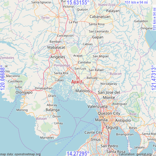
Apalit GPS coordinates[2]
14° 57' 11.988" North, 120° 46' 12" East
| Map corner | latitude | longitude |
|---|---|---|
| Upper-left | 15.63155°, | 120.06688° |
| Center: | 14.95333°, | 120.77° |
| Lower-right: | 14.27295°, | 121.47313° |
| Map W x H: | 151.1×151.1 km | = 93.9×93.9mi |
| max Lat: | 20.78733° ⇑23% North |
| Apalit: | 14.95333° |
| min Lat: | ⇓77% South 4.65442° |
| min Long | Apalit | max Long |
| 117.04868° | 120.77° | 126.58417° |
| W 17%⇐ | ⇒83% E |
Elevation
Elevation of Apalit is 14 m = 46 ft, and this is 73.9 m = 242 ft below average elevation for this country.
| Max E: |
2262 m = 7421 ft | 65.1% |
| Avg. | 87.9 m = 288 ft | |
| Apalit | 14 m = 46 ft | |
Min E: |
-2 m = -7 ft | 34.9% |
See also: Apalit elevation on elevation.city.
Geographical zone
Apalit is located in North Torrid zone (between Equator and Tropic of Cancer). Distance of this Northern Tropic circle is 943.3 km =586.1 mi to North.| Distance of | km | miles | from Apalit |
|---|---|---|---|
| North Pole | 8344.4 | 5185 | to North |
| Arctic Circle | 5738.5 | 3565.7 | to North |
| Tropic Cancer | 943.3 | 586.1 | to North |
| Equator | 1662.7 | 1033.2 | to South |


Nearby cities:
15 places around Apalit: (largest is in red/bold)
• Balite
6.7 km =4.2 mi,  164°
164°
• Balucuc
4.8 km =3 mi,  90°
90°
• Calumpit
4.1 km =2.5 mi,  186°
186°
• Dampol
8 km =5 mi,  136°
136°
• Lourdes
9.4 km =5.8 mi,  279°
279°
• Macabebe
7.7 km =4.8 mi,  229°
229°
• Masantol
9.1 km =5.7 mi, 225°
• Minalin
9.5 km =5.9 mi, 279°
• Pau
9.6 km =6 mi,  329°
329°
• San Isidro
9.3 km =5.8 mi,  35°
35°
• San Jose
9 km =5.6 mi,  9°
9°
• San Simon
5.3 km =3.3 mi, 12°
• San Vicente
2.4 km =1.5 mi,  250°
250°
• Santo Domingo
5.1 km =3.2 mi, 325°
• Santo Tomas
9.5 km =5.9 mi,  19°
19°
Sources, notices
• [Note1] Compared only with cities in Philippines existing in our database
• [Src1] Map data: © OpenStreetMap contributors (CC-BY-SA)
• [Src2] Other city data from geonames.org with taken over terms of usage.
• [Src3] Geographical zone / Annual Mean Temperature by Robert A. Rohde @ Wikipedia
