Plaridel geodata
Plaridel (Central Luzon) is a seat of a third-order administrative division; located in Philippines in Asia/Manila (GMT+8) time zone. With population of 70,781 people, there are 130 cities with bigger population in this country. Compared to other cities in Philippines, 76.3% of cities are located further ↓South; 80.9% of cities are located further →East and 65.1% of cities have higher elevation than Plaridel. Note1


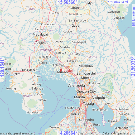
Plaridel GPS coordinates[2]
14° 53' 13.992" North, 120° 51' 25.992" East
| Map corner | latitude | longitude |
|---|---|---|
| Upper-left | 15.56566°, | 120.1541° |
| Center: | 14.88722°, | 120.85722° |
| Lower-right: | 14.20664°, | 121.56035° |
| Map W x H: | 151.1×151.1 km | = 93.9×93.9mi |
| max Lat: | 20.78733° ⇑23.7% North |
| Plaridel: | 14.88722° |
| min Lat: | ⇓76.3% South 4.65442° |
| min Long | Plaridel | max Long |
| 117.04868° | 120.85722° | 126.58417° |
| W 19.1%⇐ | ⇒80.9% E |
Elevation
Elevation of Plaridel is 14 m = 46 ft, and this is 73.9 m = 242 ft below average elevation for this country.
| Max E: |
2262 m = 7421 ft | 65.1% |
| Avg. | 87.9 m = 288 ft | |
| Plaridel | 14 m = 46 ft | |
Min E: |
-2 m = -7 ft | 34.9% |
See also: Plaridel elevation on elevation.city.
Geographical zone
Plaridel is located in North Torrid zone (between Equator and Tropic of Cancer). Distance of this Northern Tropic circle is 950.6 km =590.7 mi to North.| Distance of | km | miles | from Plaridel |
|---|---|---|---|
| North Pole | 8351.8 | 5189.6 | to North |
| Arctic Circle | 5745.9 | 3570.3 | to North |
| Tropic Cancer | 950.6 | 590.7 | to North |
| Equator | 1655.3 | 1028.6 | to South |


Nearby cities:
15 places around Plaridel: (largest is in red/bold)
• Bagong Barrio
9 km =5.6 mi,  88°
88°
• Balagtas
7.9 km =4.9 mi,  172°
172°
• Balite
7.6 km =4.7 mi,  276°
276°
• Baliuag
8.6 km =5.3 mi,  29°
29°
• Balucuc
8.6 km =5.3 mi,  327°
327°
• Bulihan
4.3 km =2.7 mi,  107°
107°
• Culianin
5.4 km =3.4 mi,  55°
55°
• Dampol
4.1 km =2.5 mi,  292°
292°
• Guiguinto
6.6 km =4.1 mi,  154°
154°
• Liciada
8.6 km =5.3 mi,  69°
69°
• Malolos
6.9 km =4.3 mi,  226°
226°
• Manatal
6.5 km =4 mi,  100°
100°
• Paombong
9.6 km =6 mi, 229°
• Pulilan
1.8 km =1.1 mi, 331°
• Pulong Gubat
6.1 km =3.8 mi,  120°
120°
Sources, notices
• [Note1] Compared only with cities in Philippines existing in our database
• [Src1] Map data: © OpenStreetMap contributors (CC-BY-SA)
• [Src2] Other city data from geonames.org with taken over terms of usage.
• [Src3] Geographical zone / Annual Mean Temperature by Robert A. Rohde @ Wikipedia
