Santo Domingo geodata
Santo Domingo (Central Luzon) is a populated place; located in Philippines in Asia/Manila (GMT+8) time zone. With population of 5,045 people, there are 1279 cities with bigger population in this country. Compared to other cities in Philippines, 77.4% of cities are located further ↓South; 83.7% of cities are located further →East and 85.4% of cities have higher elevation than Santo Domingo. Note1


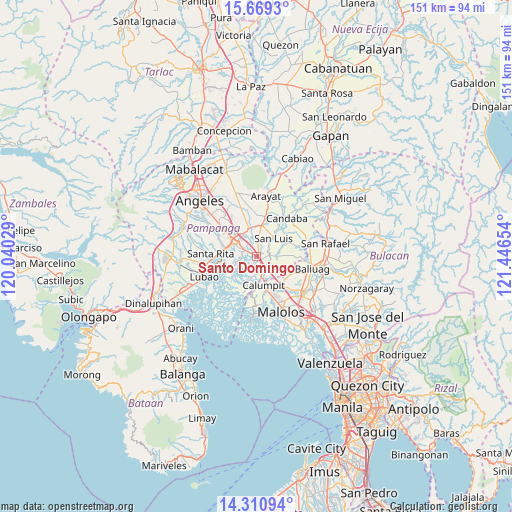
Santo Domingo GPS coordinates[2]
14° 59' 28.32" North, 120° 44' 36.276" East
| Map corner | latitude | longitude |
|---|---|---|
| Upper-left | 15.6693°, | 120.04029° |
| Center: | 14.9912°, | 120.74341° |
| Lower-right: | 14.31094°, | 121.44654° |
| Map W x H: | 151×151 km | = 93.8×93.8mi |
| max Lat: | 20.78733° ⇑22.6% North |
| Santo Domingo: | 14.9912° |
| min Lat: | ⇓77.4% South 4.65442° |
| min Long | Santo Domingo | max Long |
| 117.04868° | 120.74341° | 126.58417° |
| W 16.3%⇐ | ⇒83.7% E |
Elevation
Elevation of Santo Domingo is 8 m = 26 ft, and this is 79.9 m = 262 ft below average elevation for this country.
| Max E: |
2262 m = 7421 ft | 85.4% |
| Avg. | 87.9 m = 288 ft | |
| Santo Domingo | 8 m = 26 ft | |
Min E: |
-2 m = -7 ft | 14.6% |
See also: Philippines elevation on elevation.city.
Geographical zone
Santo Domingo is located in North Torrid zone (between Equator and Tropic of Cancer). Distance of this Northern Tropic circle is 939.1 km =583.5 mi to North.| Distance of | km | miles | from Santo Domingo |
|---|---|---|---|
| North Pole | 8340.2 | 5182.4 | to North |
| Arctic Circle | 5734.3 | 3563.1 | to North |
| Tropic Cancer | 939.1 | 583.5 | to North |
| Equator | 1666.9 | 1035.8 | to South |


Nearby cities:
15 places around Santo Domingo: (largest is in red/bold)
• Apalit
5.1 km =3.2 mi,  145°
145°
• Del Pilar
6.9 km =4.3 mi,  316°
316°
• Laug
6.2 km =3.9 mi,  8°
8°
• Lourdes
7 km =4.3 mi,  247°
247°
• Minalin
7 km =4.3 mi, 248°
• Pau
4.6 km =2.9 mi,  333°
333°
• San Carlos
5.8 km =3.6 mi,  21°
21°
• San Fernando
7.9 km =4.9 mi,  307°
307°
• San Jose
6.3 km =3.9 mi,  42°
42°
• San Juan
8 km =5 mi,  296°
296°
• San Luis
7.3 km =4.5 mi, 41°
• San Nicolas
7.9 km =4.9 mi, 44°
• San Simon
4.1 km =2.5 mi,  76°
76°
• San Vicente
5.1 km =3.2 mi,  173°
173°
• Santo Tomas
7.7 km =4.8 mi,  52°
52°
Sources, notices
• [Note1] Compared only with cities in Philippines existing in our database
• [Src1] Map data: © OpenStreetMap contributors (CC-BY-SA)
• [Src2] Other city data from geonames.org with taken over terms of usage.
• [Src3] Geographical zone / Annual Mean Temperature by Robert A. Rohde @ Wikipedia
