Balete geodata
Balete (Western Visayas) is a seat of a third-order administrative division; located in Philippines in Asia/Manila (GMT+8) time zone. In our database, there are 4166 cities with bigger population. Compared to other cities in Philippines, 50.8% of cities are located further ↑North; 56.4% of cities are located further →East and 80.7% of cities have higher elevation than Balete. Note1


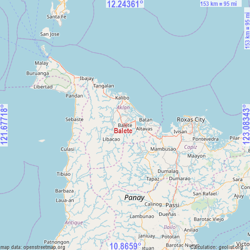
Balete GPS coordinates[2]
11° 33' 20.16" North, 122° 22' 49.08" East
| Map corner | latitude | longitude |
|---|---|---|
| Upper-left | 12.24361°, | 121.67718° |
| Center: | 11.5556°, | 122.3803° |
| Lower-right: | 10.8659°, | 123.08343° |
| Map W x H: | 153.2×153.2 km | = 95.2×95.2mi |
| max Lat: | 20.78733° ⇑50.8% North |
| Balete: | 11.5556° |
| min Lat: | ⇓49.2% South 4.65442° |
| min Long | Balete | max Long |
| 117.04868° | 122.3803° | 126.58417° |
| W 43.6%⇐ | ⇒56.4% E |
Elevation
Elevation of Balete is 9 m = 30 ft, and this is 78.9 m = 259 ft below average elevation for this country.
| Max E: |
2262 m = 7421 ft | 80.7% |
| Avg. | 87.9 m = 288 ft | |
| Balete | 9 m = 30 ft | |
Min E: |
-2 m = -7 ft | 19.3% |
See also: Philippines elevation on elevation.city.
Geographical zone
Balete is located in North Torrid zone (between Equator and Tropic of Cancer). Distance of Equator is 1284.9 km =798.4 mi to South.| Distance of | km | miles | from Balete |
|---|---|---|---|
| North Pole | 8722.2 | 5419.7 | to North |
| Arctic Circle | 6116.3 | 3800.5 | to North |
| Tropic Cancer | 1321.1 | 820.9 | to North |
| Equator | 1284.9 | 798.4 | to South |


Nearby cities:
15 places around Balete: (largest is in red/bold)
• Aranas Sur
1.4 km =0.9 mi,  50°
50°
• Arcangel
4.2 km =2.6 mi,  244°
244°
• Bañga
10.5 km =6.5 mi,  331°
331°
• Calizo
3 km =1.9 mi,  11°
11°
• Cortez
3.4 km =2.1 mi,  146°
146°
• Feliciano
3.5 km =2.2 mi,  316°
316°
• Lalab
5.7 km =3.5 mi,  67°
67°
• Linabuan
10.9 km =6.8 mi,  346°
346°
• Linabuan Sur
11.3 km =7 mi,  340°
340°
• Madalag
8.6 km =5.3 mi,  248°
248°
• Morales
1.2 km =0.7 mi,  200°
200°
• Odiong
9.7 km =6 mi,  103°
103°
• Polo
8.1 km =5 mi,  293°
293°
• Rosario
9.1 km =5.7 mi, 289°
• Tugas
6.4 km =4 mi,  1°
1°
Sources, notices
• [Note1] Compared only with cities in Philippines existing in our database
• [Src1] Map data: © OpenStreetMap contributors (CC-BY-SA)
• [Src2] Other city data from geonames.org with taken over terms of usage.
• [Src3] Geographical zone / Annual Mean Temperature by Robert A. Rohde @ Wikipedia
