Bañga geodata
Bañga (Western Visayas) is a populated place; located in Philippines in Asia/Manila (GMT+8) time zone. With population of 2,136 people, there are 4020 cities with bigger population in this country. Compared to other cities in Philippines, 50% of cities are located further ↓South; 56.9% of cities are located further →East and 53.1% of cities have higher elevation than Bañga. Note1


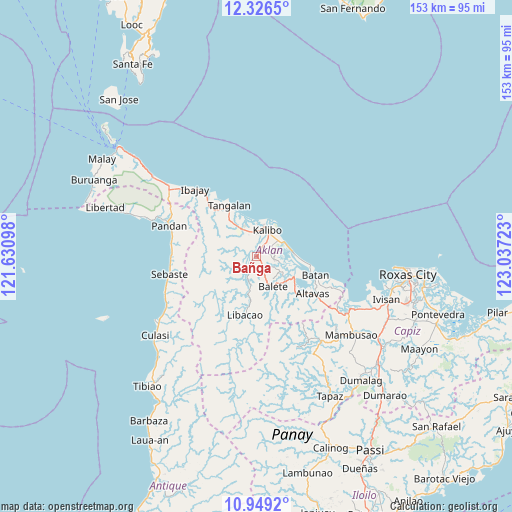
Bañga GPS coordinates[2]
11° 38' 19.32" North, 122° 20' 2.76" East
| Map corner | latitude | longitude |
|---|---|---|
| Upper-left | 12.3265°, | 121.63098° |
| Center: | 11.6387°, | 122.3341° |
| Lower-right: | 10.9492°, | 123.03723° |
| Map W x H: | 153.1×153.1 km | = 95.1×95.1mi |
| max Lat: | 20.78733° ⇑50% North |
| Bañga: | 11.6387° |
| min Lat: | ⇓50% South 4.65442° |
| min Long | Bañga | max Long |
| 117.04868° | 122.3341° | 126.58417° |
| W 43.1%⇐ | ⇒56.9% E |
Elevation
Elevation of Bañga is 21 m = 69 ft, and this is 66.9 m = 219 ft below average elevation for this country.
| Max E: |
2262 m = 7421 ft | 53.1% |
| Avg. | 87.9 m = 288 ft | |
| Bañga | 21 m = 69 ft | |
Min E: |
-2 m = -7 ft | 46.9% |
See also: Philippines elevation on elevation.city.
Geographical zone
Bañga is located in North Torrid zone (between Equator and Tropic of Cancer). Distance of Equator is 1294.1 km =804.1 mi to South.| Distance of | km | miles | from Bañga |
|---|---|---|---|
| North Pole | 8713 | 5414 | to North |
| Arctic Circle | 6107.1 | 3794.8 | to North |
| Tropic Cancer | 1311.8 | 815.1 | to North |
| Equator | 1294.1 | 804.1 | to South |


Nearby cities:
15 places around Bañga: (largest is in red/bold)
• Brgy. Bubog, Numancia
8.1 km =5 mi,  12°
12°
• Brgy. Nalook, kalibo
6.5 km =4 mi,  36°
36°
• Brgy. Tinigao, Kalibo
7.7 km =4.8 mi,  27°
27°
• Calizo
8.5 km =5.3 mi,  138°
138°
• Cayanguan
7.3 km =4.5 mi,  319°
319°
• Feliciano
7.2 km =4.5 mi,  158°
158°
• Guinoaliuan
5.9 km =3.7 mi,  69°
69°
• Kalibo (poblacion)
8.2 km =5.1 mi,  23°
23°
• Linabuan
2.9 km =1.8 mi,  61°
61°
• Linabuan Sur
1.8 km =1.1 mi, 40°
• Malinao
2.9 km =1.8 mi,  281°
281°
• Numancia
7.5 km =4.7 mi,  355°
355°
• Polo
6.5 km =4 mi,  201°
201°
• Rosario
7.1 km =4.4 mi,  209°
209°
• Tugas
6 km =3.7 mi,  118°
118°
Sources, notices
• [Note1] Compared only with cities in Philippines existing in our database
• [Src1] Map data: © OpenStreetMap contributors (CC-BY-SA)
• [Src2] Other city data from geonames.org with taken over terms of usage.
• [Src3] Geographical zone / Annual Mean Temperature by Robert A. Rohde @ Wikipedia
