Tugas geodata
Tugas (Western Visayas) is a populated place; located in Philippines in Asia/Manila (GMT+8) time zone. With population of 2,072 people, there are 4115 cities with bigger population in this country. Compared to other cities in Philippines, 50.2% of cities are located further ↑North; 56.4% of cities are located further →East and 85.4% of cities have higher elevation than Tugas. Note1


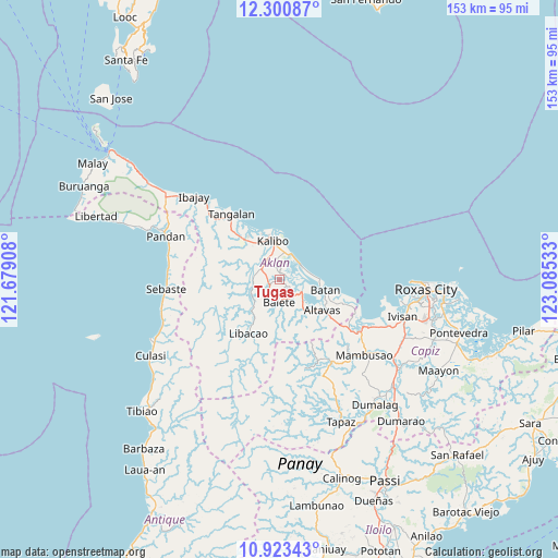
Tugas GPS coordinates[2]
11° 36' 46.8" North, 122° 22' 55.92" East
| Map corner | latitude | longitude |
|---|---|---|
| Upper-left | 12.30087°, | 121.67908° |
| Center: | 11.613°, | 122.3822° |
| Lower-right: | 10.92343°, | 123.08533° |
| Map W x H: | 153.2×153.2 km | = 95.2×95.2mi |
| max Lat: | 20.78733° ⇑50.2% North |
| Tugas: | 11.613° |
| min Lat: | ⇓49.8% South 4.65442° |
| min Long | Tugas | max Long |
| 117.04868° | 122.3822° | 126.58417° |
| W 43.6%⇐ | ⇒56.4% E |
Elevation
Elevation of Tugas is 8 m = 26 ft, and this is 79.9 m = 262 ft below average elevation for this country.
| Max E: |
2262 m = 7421 ft | 85.4% |
| Avg. | 87.9 m = 288 ft | |
| Tugas | 8 m = 26 ft | |
Min E: |
-2 m = -7 ft | 14.6% |
See also: Philippines elevation on elevation.city.
Geographical zone
Tugas is located in North Torrid zone (between Equator and Tropic of Cancer). Distance of Equator is 1291.2 km =802.3 mi to South.| Distance of | km | miles | from Tugas |
|---|---|---|---|
| North Pole | 8715.8 | 5415.7 | to North |
| Arctic Circle | 6109.9 | 3796.5 | to North |
| Tropic Cancer | 1314.7 | 816.9 | to North |
| Equator | 1291.2 | 802.3 | to South |


Nearby cities:
15 places around Tugas: (largest is in red/bold)
• Aranas Sur
5.6 km =3.5 mi,  171°
171°
• Balete
6.4 km =4 mi,  181°
181°
• Bañga
6 km =3.7 mi,  298°
298°
• Brgy. Mabilo, New Washington
7.7 km =4.8 mi,  20°
20°
• Brgy. Nalook, kalibo
8.2 km =5.1 mi,  350°
350°
• Calizo
3.5 km =2.2 mi, 173°
• Feliciano
4.6 km =2.9 mi,  214°
214°
• Guinoaliuan
5 km =3.1 mi,  3°
3°
• Lalab
6.6 km =4.1 mi,  130°
130°
• Linabuan
5 km =3.1 mi,  327°
327°
• Linabuan Sur
5.9 km =3.7 mi,  316°
316°
• Morales
7.5 km =4.7 mi, 184°
• New Washington
6.9 km =4.3 mi,  52°
52°
• Polo
8.3 km =5.2 mi,  247°
247°
• Tambac
7.1 km =4.4 mi,  26°
26°
Sources, notices
• [Note1] Compared only with cities in Philippines existing in our database
• [Src1] Map data: © OpenStreetMap contributors (CC-BY-SA)
• [Src2] Other city data from geonames.org with taken over terms of usage.
• [Src3] Geographical zone / Annual Mean Temperature by Robert A. Rohde @ Wikipedia
