Balatan geodata
Balatan (Bicol) is a seat of a third-order administrative division; located in Philippines in Asia/Manila (GMT+8) time zone. With population of 4,451 people, there are 1520 cities with bigger population in this country. Compared to other cities in Philippines, 60.3% of cities are located further ↓South; 57.1% of cities are located further ←West and 95.5% of cities have higher elevation than Balatan. Note1


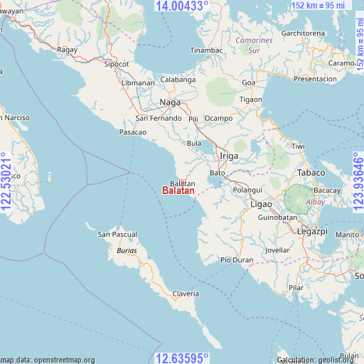
Balatan GPS coordinates[2]
13° 19' 15.996" North, 123° 13' 59.988" East
| Map corner | latitude | longitude |
|---|---|---|
| Upper-left | 14.00433°, | 122.53021° |
| Center: | 13.32111°, | 123.23333° |
| Lower-right: | 12.63595°, | 123.93646° |
| Map W x H: | 152.1×152.2 km | = 94.5×94.6mi |
| max Lat: | 20.78733° ⇑39.7% North |
| Balatan: | 13.32111° |
| min Lat: | ⇓60.3% South 4.65442° |
| min Long | Balatan | max Long |
| 117.04868° | 123.23333° | 126.58417° |
| W 57.1%⇐ | ⇒42.9% E |
Elevation
Elevation of Balatan is 5 m = 16 ft, and this is 82.9 m = 272 ft below average elevation for this country.
| Max E: |
2262 m = 7421 ft | 95.5% |
| Avg. | 87.9 m = 288 ft | |
| Balatan | 5 m = 16 ft | |
Min E: |
-2 m = -7 ft | 4.5% |
See also: Philippines elevation on elevation.city.
Geographical zone
Balatan is located in North Torrid zone (between Equator and Tropic of Cancer). Distance of this Northern Tropic circle is 1124.8 km =698.9 mi to North.| Distance of | km | miles | from Balatan |
|---|---|---|---|
| North Pole | 8525.9 | 5297.7 | to North |
| Arctic Circle | 5920 | 3678.5 | to North |
| Tropic Cancer | 1124.8 | 698.9 | to North |
| Equator | 1481.2 | 920.4 | to South |


Nearby cities:
15 places around Balatan: (largest is in red/bold)
• Agupit
15 km =9.3 mi,  41°
41°
• Balaogan
13.5 km =8.4 mi,  22°
22°
• Bato
15 km =9.3 mi,  76°
76°
• Buga
13.9 km =8.6 mi,  101°
101°
• Bula
17.3 km =10.7 mi, 16°
• Buluang
11.9 km =7.4 mi, 97°
• Del Rosario
8.8 km =5.5 mi, 101°
• Inapatan
12.8 km =8 mi,  49°
49°
• Lourdes
17 km =10.6 mi,  63°
63°
• Macabugos
12.2 km =7.6 mi,  140°
140°
• Malawag
8.8 km =5.5 mi, 38°
• Palsong
13.4 km =8.3 mi,  30°
30°
• Salingogan
13.2 km =8.2 mi,  340°
340°
• San Jose
17.1 km =10.6 mi,  119°
119°
• Tambo
9.6 km =6 mi, 139°
Sources, notices
• [Note1] Compared only with cities in Philippines existing in our database
• [Src1] Map data: © OpenStreetMap contributors (CC-BY-SA)
• [Src2] Other city data from geonames.org with taken over terms of usage.
• [Src3] Geographical zone / Annual Mean Temperature by Robert A. Rohde @ Wikipedia
