Bagroy geodata
Bagroy (Western Visayas) is a populated place; located in Philippines in Asia/Manila (GMT+8) time zone. With population of 2,361 people, there are 3533 cities with bigger population in this country. Compared to other cities in Philippines, 66.3% of cities are located further ↑North; 52.1% of cities are located further ←West and 67.4% of cities have higher elevation than Bagroy. Note1
Administrative division(s):
- Level 1: Western Visayas
- Level 2: Province of Negros Occidental
- Level 3: Binalbagan


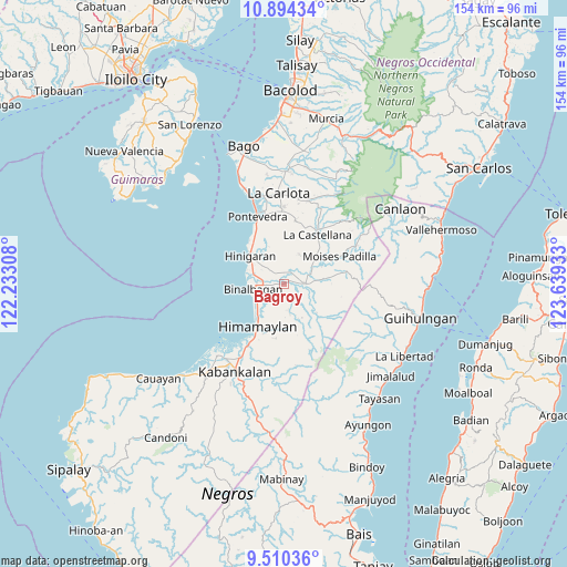
Bagroy GPS coordinates[2]
10° 12' 11.16" North, 122° 56' 10.32" East
| Map corner | latitude | longitude |
|---|---|---|
| Upper-left | 10.89434°, | 122.23308° |
| Center: | 10.2031°, | 122.9362° |
| Lower-right: | 9.51036°, | 123.63933° |
| Map W x H: | 153.9×153.9 km | = 95.6×95.6mi |
| max Lat: | 20.78733° ⇑66.3% North |
| Bagroy: | 10.2031° |
| min Lat: | ⇓33.7% South 4.65442° |
| min Long | Bagroy | max Long |
| 117.04868° | 122.9362° | 126.58417° |
| W 52.1%⇐ | ⇒47.9% E |
Elevation
Elevation of Bagroy is 13 m = 43 ft, and this is 74.9 m = 246 ft below average elevation for this country.
| Max E: |
2262 m = 7421 ft | 67.4% |
| Avg. | 87.9 m = 288 ft | |
| Bagroy | 13 m = 43 ft | |
Min E: |
-2 m = -7 ft | 32.6% |
See also: Philippines elevation on elevation.city.
Geographical zone
Bagroy is located in North Torrid zone (between Equator and Tropic of Cancer). Distance of Equator is 1134.5 km =704.9 mi to South.| Distance of | km | miles | from Bagroy |
|---|---|---|---|
| North Pole | 8872.6 | 5513.2 | to North |
| Arctic Circle | 6266.7 | 3893.9 | to North |
| Tropic Cancer | 1471.4 | 914.3 | to North |
| Equator | 1134.5 | 704.9 | to South |


Nearby cities:
15 places around Bagroy: (largest is in red/bold)
• Aranda
3.9 km =2.4 mi,  17°
17°
• Binalbagan
8.6 km =5.3 mi,  263°
263°
• Bulad
8.9 km =5.5 mi,  49°
49°
• Cabadiangan
6.4 km =4 mi,  173°
173°
• Calape
8.9 km =5.5 mi,  28°
28°
• Camalobalo
7.9 km =4.9 mi,  11°
11°
• Camangcamang
6.1 km =3.8 mi,  115°
115°
• Guintubhan
2.9 km =1.8 mi,  80°
80°
• Isabela
5.8 km =3.6 mi,  88°
88°
• Libacao
3.6 km =2.2 mi,  223°
223°
• Marawis
7.1 km =4.4 mi,  311°
311°
• Montilla
1.1 km =0.7 mi,  267°
267°
• Patique
5.5 km =3.4 mi, 313°
• Payao
3.1 km =1.9 mi,  206°
206°
• Santol
7.2 km =4.5 mi, 117°
Sources, notices
• [Note1] Compared only with cities in Philippines existing in our database
• [Src1] Map data: © OpenStreetMap contributors (CC-BY-SA)
• [Src2] Other city data from geonames.org with taken over terms of usage.
• [Src3] Geographical zone / Annual Mean Temperature by Robert A. Rohde @ Wikipedia
