Awang geodata
Awang (Autonomous Region in Muslim Mindanao) is a populated place; located in Philippines in Asia/Manila (GMT+8) time zone. With population of 8,417 people, there are 738 cities with bigger population in this country. Compared to other cities in Philippines, 90% of cities are located further ↑North; 74.2% of cities are located further ←West and 74.3% of cities have lower elevation than Awang. Note1
Administrative division(s):
- Level 1: Autonomous Region in Muslim Mindanao
- Level 2: Province of Maguindanao
- Level 3: Datu Odin Sinsuat (Dinaig)


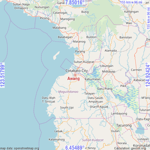
Awang GPS coordinates[2]
7° 9' 11.016" North, 124° 13' 15.996" East
| Map corner | latitude | longitude |
|---|---|---|
| Upper-left | 7.85016°, | 123.51799° |
| Center: | 7.15306°, | 124.22111° |
| Lower-right: | 6.45489°, | 124.92424° |
| Map W x H: | 155.1×155.1 km | = 96.4×96.4mi |
| max Lat: | 20.78733° ⇑90% North |
| Awang: | 7.15306° |
| min Lat: | ⇓10% South 4.65442° |
| min Long | Awang | max Long |
| 117.04868° | 124.22111° | 126.58417° |
| W 74.2%⇐ | ⇒25.8% E |
Elevation
Elevation of Awang is 66 m = 217 ft, and this is 21.9 m = 72 ft below average elevation for this country.
| Max E: |
2262 m = 7421 ft | 25.7% |
| Avg. | 87.9 m = 288 ft | |
| Awang | 66 m = 217 ft | |
Min E: |
-2 m = -7 ft | 74.3% |
See also: Philippines elevation on elevation.city.
Geographical zone
Awang is located in North Torrid zone (between Equator and Tropic of Cancer). Distance of Equator is 795.3 km =494.2 mi to South.| Distance of | km | miles | from Awang |
|---|---|---|---|
| North Pole | 9211.7 | 5723.9 | to North |
| Arctic Circle | 6605.8 | 4104.7 | to North |
| Tropic Cancer | 1810.6 | 1125.1 | to North |
| Equator | 795.3 | 494.2 | to South |


Nearby cities:
15 places around Awang: (largest is in red/bold)
• Baka
14.5 km =9 mi,  19°
19°
• Blinsung
15.7 km =9.8 mi,  196°
196°
• Cotabato
8.3 km =5.2 mi, 19°
• Dadus
15.4 km =9.6 mi,  133°
133°
• Dalumangcob
11.2 km =7 mi,  50°
50°
• Gang
11.5 km =7.1 mi,  25°
25°
• Katidtuan
11.1 km =6.9 mi,  69°
69°
• Labuñgan
5.8 km =3.6 mi,  164°
164°
• Limbo
11.2 km =7 mi,  12°
12°
• Pinaring
13 km =8.1 mi, 49°
• Salimbao
8.5 km =5.3 mi, 24°
• Sultan Kudarat
9.4 km =5.8 mi, 25°
• Tamontaka
3.1 km =1.9 mi, 9°
• Taviran
11.4 km =7.1 mi,  106°
106°
• Upi
15.4 km =9.6 mi, 203°
Sources, notices
• [Note1] Compared only with cities in Philippines existing in our database
• [Src1] Map data: © OpenStreetMap contributors (CC-BY-SA)
• [Src2] Other city data from geonames.org with taken over terms of usage.
• [Src3] Geographical zone / Annual Mean Temperature by Robert A. Rohde @ Wikipedia
