Gang geodata
Gang (Autonomous Region in Muslim Mindanao) is a populated place; located in Philippines in Asia/Manila (GMT+8) time zone. With population of 3,317 people, there are 2206 cities with bigger population in this country. Compared to other cities in Philippines, 89% of cities are located further ↑North; 74.9% of cities are located further ←West and 76.6% of cities have higher elevation than Gang. Note1
Administrative division(s):
- Level 1: Autonomous Region in Muslim Mindanao
- Level 2: Province of Maguindanao
- Level 3: Sultan Kudarat (Nuling)


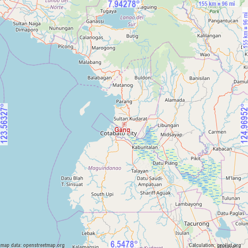
Gang GPS coordinates[2]
7° 14' 44.988" North, 124° 15' 59.004" East
| Map corner | latitude | longitude |
|---|---|---|
| Upper-left | 7.94278°, | 123.56327° |
| Center: | 7.24583°, | 124.26639° |
| Lower-right: | 6.5478°, | 124.96952° |
| Map W x H: | 155.1×155.1 km | = 96.4×96.4mi |
| max Lat: | 20.78733° ⇑89% North |
| Gang: | 7.24583° |
| min Lat: | ⇓11% South 4.65442° |
| min Long | Gang | max Long |
| 117.04868° | 124.26639° | 126.58417° |
| W 74.9%⇐ | ⇒25.1% E |
Elevation
Elevation of Gang is 10 m = 33 ft, and this is 77.9 m = 256 ft below average elevation for this country.
| Max E: |
2262 m = 7421 ft | 76.6% |
| Avg. | 87.9 m = 288 ft | |
| Gang | 10 m = 33 ft | |
Min E: |
-2 m = -7 ft | 23.4% |
See also: Philippines elevation on elevation.city.
Geographical zone
Gang is located in North Torrid zone (between Equator and Tropic of Cancer). Distance of Equator is 805.7 km =500.6 mi to South.| Distance of | km | miles | from Gang |
|---|---|---|---|
| North Pole | 9201.4 | 5717.5 | to North |
| Arctic Circle | 6595.5 | 4098.3 | to North |
| Tropic Cancer | 1800.3 | 1118.7 | to North |
| Equator | 805.7 | 500.6 | to South |


Nearby cities:
15 places around Gang: (largest is in red/bold)
• Awang
11.5 km =7.1 mi,  205°
205°
• Baka
3.4 km =2.1 mi,  355°
355°
• Cotabato
3.3 km =2.1 mi,  221°
221°
• Dalumangcob
4.9 km =3 mi,  131°
131°
• Katidtuan
8.3 km =5.2 mi,  139°
139°
• Limbo
2.6 km =1.6 mi,  284°
284°
• Parang
13.9 km =8.6 mi,  1°
1°
• Pinaring
5.2 km =3.2 mi,  111°
111°
• Polloc
13 km =8.1 mi,  337°
337°
• Salimbao
3 km =1.9 mi, 209°
• Simuay
5.7 km =3.5 mi,  52°
52°
• Sultan Kudarat
2.1 km =1.3 mi, 206°
• Tamontaka
8.5 km =5.3 mi, 211°
• Tapayan
5.4 km =3.4 mi, 359°
• Taviran
14.8 km =9.2 mi,  156°
156°
Sources, notices
• [Note1] Compared only with cities in Philippines existing in our database
• [Src1] Map data: © OpenStreetMap contributors (CC-BY-SA)
• [Src2] Other city data from geonames.org with taken over terms of usage.
• [Src3] Geographical zone / Annual Mean Temperature by Robert A. Rohde @ Wikipedia
